Why in news?
- China has released the 2023 edition of its “standard map”, staking a claim over Arunachal Pradesh, Aksai Chin region, Taiwan and the disputed South China Sea.
- Hours after the release of map, India lodged a strong protest through diplomatic channels.
What’s in today’s article?
- India – China Border Dispute
- News Summary
India – China Border Dispute
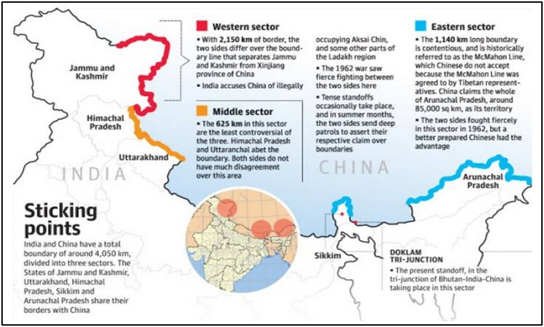
- Western Sector (Disputed sector) –
- This comprises the Aksai Chin sector. A region that originally was a part of the state of Jammu and Kashmir is claimed by China as part of its autonomous Xinjiang region.
- After the 1962 war, it is administered by China. It is the second largest Indo-China border area covering over 38000 sq. km. However, it is an uninhabited land.
- While India claims the entire Aksai Chin territory as well as the Shaksgam valley (Indian territory gifted to China by Pakistan), China contests Indian control over Daulat Beg Oldi (a tehsil in Leh, south of Aksai China - it is believed to host the world’s highest airstrip).
- Central Sector
- The 625 km boundary of this sector is least controversial between two nations.
- There is no major disagreement over boundary in this region between two countries.
- Border Dispute in Eastern Sector: McMahon Line
- The disputed boundary in the Eastern Sector of the India-China border is over the McMahon Line.
- Representatives of China, India and Tibet in 1913-14 met in Shimla to settle the boundary between Tibet and India, and Tibet and China.
- During the Shimla conference, Sir Henry McMahon, the then foreign secretary of British India, drew up the 550 mile (890 km) McMahon Line as the border between British India and Tibet.
- The McMahon line moved British control substantially northwards. This agreement ceded Tawang and other Tibetan areas to the imperial British Empire.
- Though the Chinese representatives at the meeting initialled the agreement, they subsequently refused to accept it.
- Subsequently, the Chinese government stated that it does not recognize the "illegal" McMahon Line.
- China accuses India of occupying areas in Arunachal, which it calls part of Southern Tibet.
- The Arunachal Pradesh border, that China claims to be its own territory, is the largest disputed area, covering around 90000 sq. km.
- During the 1962 war, the People’s Liberation Army occupied it but they announced a unilateral ceasefire and withdrew respecting the McMahon Line.
- Recent aggressive actions of China in eastern sector
- As part of the Chinese strategy to assert its territorial claims over Indian territory, Beijing, in January 2022, announced Chinese names for 15 places in Arunachal Pradesh.
- China’s national legislature in October 20221 adopted a new law on the protection and exploitation of the land border areas that came into effect on January 1, 2022.
- The new law formalises some of China’s recent actions in disputed territories with both India and Bhutan.
- It has deployed a high number of reserve troops along the LAC in the Eastern Command and has conducted annual training exercises of longer duration in depth areas.
- Besides increased patrolling activities in the region, it has constructed dual-use border villages and troop habitats which can be used by both military and civilians.
- It also provides stapled visa to the people from Arunachal Pradesh.
- Steps taken by India to counter Chinese threat in eastern sector
- India is ensuring full operational preparedness to take care of any contingency.
- It is working towards mitigating the threat to the vulnerable Chicken’s Neck area.
- Chicken’s Neck area or the Siliguri Corridor is the narrow strip of land that connect the North-east with rest of India.
- India has also miximised the use of for ISR (intelligence, surveillance and reconnaissance).
- India raised a new aviation brigade in the eastern sectorin 2021.
- Situated at at Missamari in Assam,the brigade is mandated with the task of increasing surveillance along the LAC in the eastern sector.
- India has based the second Rafale fighter squadron in Hasimara (close to the Sikkim-Bhutan-Tibet tri-junction).
- Sukhoi-30MKI jets are already deployed at air bases like Tezpur and Chabua.
- Akash surface-to-air missile systems along with Bofors howitzers have been deployed.
News Summary: China includes Arunachal Pradesh, Aksai Chin area in new map
- China released the 2023 edition of its standard map based on the drawing method of national boundaries of China and various countries in the world.
- The map showed Arunachal Pradesh, which China claims as South Tibet, and Aksai Chin occupied by it in the 1962 war.
- The map also incorporated Taiwan, which China claims as part of its territory though the island sees itself as a sovereign nation, and the nine-dash line, claiming a large part of the South China Sea.
- In a rebuttal to newly released Chinese map, Union External Affairs Minister S Jaishankar said that making absurd claims over territories wouldn’t make them theirs.

