Why in News?
The recent thrust on developing strategic infrastructure, both civilian and military, on the Andaman and Nicobar (A&N) islands is welcome and decades overdue.
The way this important group of islands has been neglected during the decades following Independence indicates a lack of strategic maritime vision.
What’s in Today’s Article?
- Strategic Location of the A&N Islands:
- What is the Strategic Significance of the A&N Islands?
- Why has the Pace of Developing Strategic Infrastructure in A&N Been Slow?
- What Should Strategic Infrastructure Development in these Islands Focus On?
- What Kind of Infrastructure should be Prioritised on the Islands?
Strategic Location of the A&N Islands:
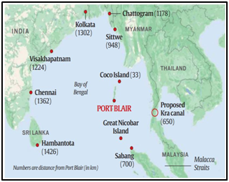
- The islands are located 700 nautical miles (1,300 km) southeast of the Indian mainland.
- The Malacca Strait, the main waterway that connects the Indian Ocean to the Pacific, is less than a day’s steaming from Port Blair.
- Sabang in Indonesia is 90 nautical miles southeast of Indira Point (on Great Nicobar island), and Coco Island (Myanmar) is barely 18 nautical miles from the northernmost tip of the Andamans.
- The mouth of the Kra Canal (to be built by Thailand to connect the Gulf of Thailand with the Andaman Sea) would be located roughly 350 nautical miles east of Port Blair.
- The islands share four of India’s international maritime zonedelimitations with Myanmar, Thailand, Indonesia and Bangladesh.
- They also give India substantial ocean space under the United Nations Conference on the Laws of the Sea (UNCLOS) in terms of exclusive economic zone and continental shelf.
What is the Strategic Significance of the A&N Islands?
- The following has brought a degree of seriousness to the imperative of developing the A&N group of Islands -
- The transformation of India’s Look East policy into a robust Act East policy,
- A realisation of the critical importance of ocean power, and
- The rapid enhancement in the capabilities of the Chinese PLA Navy.
- In the foreseeable future, a serious challenge could emanate from a build-up of Chinese maritime forces at the eastern choke points of the Indo-Pacific, namely
- The Malacca (between Sumatra and the Malay peninsula),
- Sunda (between Java and Sumatra),
- Lombok (between Bali and Lombok), and
- Ombai-Wetar (off East Timor) straits.
- The A&N Islands should be the first line of offence against any attempt from the East to undermine India’s maritime security.
- While some effort was made to leverage this locational advantage with the A&N Command (ANC) being constituted as a tri-services command in 2001, subsequent efforts have been grossly inadequate.
Why has the Pace of Developing Strategic Infrastructure in A&N Been Slow?
- Non-realisation of strategic importance for India’s security: Political decision-makers have very recently realised how vitally important the islands are. This is because of the PLA Navy's unprecedented expansion.
- The distance from the mainland: It has been used as an excuse to delay and stall various projects.
- Complex procedures for obtaining environmental clearances: Regulations on the conservation of forests and native tribes have complicated issues of land acquisition.
- Coordination challenges: The development of islands and strategic infrastructure is a multi-dimensional project involving several ministries, departments, and agencies.
- Not a political issue: The conflict between a long-term strategic vision and immediate political gains has often tilted in favour of the latter.
What Should Strategic Infrastructure Development in these Islands Focus On?
- Maritime security: The security of all 836 islands, both inhabited and uninhabited, must be ensured against attempts at their occupation or use by entities engaged in unlawful activities.
- A strong element of deterrence: It must be ensured against any naval misadventure from the East.
- Bolster India’s maritime economy: Infrastructure must be built on the southern group of islands that is strategically located vis-à-vis the main shipping lane from the Indian Ocean to South East Asia.
- Ease of travel to and between the islands: Improved transportation will help to create and sustain the tourism potential of the islands.
- Islands’ dependence on mainland support must be reduced: In respect of foodstuffs or relevant local industries that support maintenance, repair, and other services.
What Kind of Infrastructure should be Prioritised on the Islands?
- This sea area needs to be monitored and patrolled by aircraft and surface platforms.
- Separate airfields with long runways that can operate Boeing 737-sized aircraft are essential.
- Ports and fuel storages must be built in both the northern and southern groups of the islands for ships’ operational turnaround without the need to return to Port Blair.
- The Army, Navy, and Air Force must not only commit more forces, but station the right mix of assets at the ANC. There is a need to base surveillance and fighter aircraft there.
- Work on the Galathea Bay (Great Nicobar Island) transhipment port must be expedited.
- India could also explore the possibility of leveraging international arrangements in the Indo-Pacific such as the Quad and the Indo-Pacific Oceans Initiative (IPOI) to catalyse development efforts on the islands.

