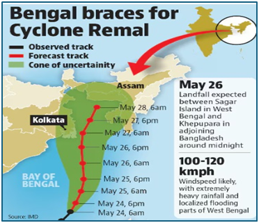
Why in news? Cyclonic storm “Remal”, originating in the central Bay of Bengal, is expected to escalate into a severe cyclonic storm by May 25. As per the IMD, the cyclone is expected to make landfall between Sagar Island in West Bengal and Khepupara in Bangladesh around the midnight of May 26.
What’s in today’s article?
- Cyclone
- Landfall of a cyclone
- Bay of Bengal: a cyclone hotspot
- Cyclone management – Steps taken by India
- Cyclone Remal
Cyclone
- About
- A cyclone is a large-scale system of air that rotates around the centre of a low-pressure area. It is usually accompanied by violent storms and bad weather.
- It is characterised by inward spiralling winds that rotate anticlockwise in the Northern Hemisphere and clockwise in the Southern Hemisphere.
- Characteristics of a Tropical Cyclone:
- The centre of a cyclone is very calm and clear with very low air pressure. The average speed is 120 kmph.
- They have closed isobars which leads to greater velocity.
- Isobars are imaginary lines on a weather map that connect locations with equal atmospheric pressure.
- They develop over oceans and sea only. They are seasonal in nature.
- They move from east to west under the influence of trade winds.
- Classification of cyclones
- Cyclones are classified on the basis of wind speed by the Indian Meteorological Department (IMD):
- Depression: Wind speeds of between 31–49 km/h
- Deep Depression: Between 50-61 km/h
- Cyclonic Storm: Between 62–88 km/h
- Severe Cyclonic Storm: Between 89-117 Km/h
- Very Severe Cyclonic Storm: Between 118-166 Km/h
- Extremely Severe Cyclonic Storm: Between 167-221 Km/h
- Super Cyclonic Storm: Above 222 Km/h
Landfall of a cyclone
- Landfall is the event of a tropical cyclone coming onto land after being over water.
- As per the IMD, a tropical cyclone is said to have made a landfall when the center of the storm – or its eye – moves over the coast.
- The "eye" of a cyclone is a region of relatively calm weather found at the center of the storm.
- It is a circular or oval-shaped area characterized by light winds, clear or partly cloudy skies, and decreased precipitation.
- Within the eye, winds are light and variable, often with clear or only partially cloudy skies.
- The size of the eye can vary significantly, ranging from a few kilometers to over 50 kilometers (30 miles) in diameter in larger cyclones.
- During landfall, the outer bands of the storm may have already reached the coast, bringing strong winds, heavy rain, and storm surge.
- A landfall should not be confused with a ‘direct hit’, which refers to a situation where the core of high winds (or eyewall) comes onshore but the centre of the storm may stay remain offshore.
Bay of Bengal: a cyclone hotspot
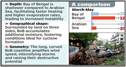
- Historical data underscore Bay of Bengal’s predisposition to cyclones, with approximately 58% of them making landfall on India’s eastern coast, compared to just 25% in the Arabian Sea.
- The Arabian Sea gets fewer cyclones due to its narrower and deeper nature, cooler water and higher salinity. Its partially landlocked geography also contributes to reduced cyclonic activity.
Cyclone management – Steps taken by India
- National Cyclone Risk Mitigation Project (NCRMP):
- Launched by the MHA, this project aims to reduce the vulnerability of coastal communities and infrastructure to cyclones and storm surges.
- It focuses on capacity building, early warning systems, cyclone shelters, evacuation planning, and community awareness.
- IMD’s Colour Coding of Cyclones: Four colours - Green, Yellow, Orange, and Red – are used by IMD to make people aware about the severity of cyclones.
- Integrated Coastal Zone Management (ICZM) Project
- Coastal Regulation Zones (CRZ)
- Other general steps taken:
- National Disaster Response Force (NDRF)
- National Disaster Management Plan (NDMP)
- National Institute of Disaster Management (NIDM)
- State Disaster Management Authorities (SDMAs)
Cyclone Remal
- Coordination efforts are underway
- To ensure the safety of maritime traffic, the Coast Guard’s remote operating stations at Haldia and Paradip are broadcasting regular and multilingual VHF (very high frequency) alerts.
- Merchant vessels at anchorages have been alerted, and port authorities have been advised to take appropriate actions.
- Nine disaster relief teams have been positioned at strategic locations, including Haldia, Paradip, Gopalpur, and Frazerganj.
- Fishing activities have been banned.
- West Bengal has a high adaptive capacity against cyclones because of cyclone multi-hazard Early Warning Systems (EWS).
- EWS is made available under the National Cyclone Risk Mitigation Project (NCRMP) Phase II.
- The state’s high tele-density ratio allows people to access early warnings via telephone or mobile.

