In News:
- With an aim to promote the civilian use of NAVigation with the Indian Constellation (NavIC), ISRO is introducing the L1 frequency in all its future satellites.
- This was highlighted by the Union Minister of State for the Department of Space Jitendra Singh in a written reply in Parliament.
What’s in today’s article:
- NAVigation with the Indian Constellation (NavIC) – about, features, comparison
- News Summary
NAVigation with the Indian Constellation (NavIC)
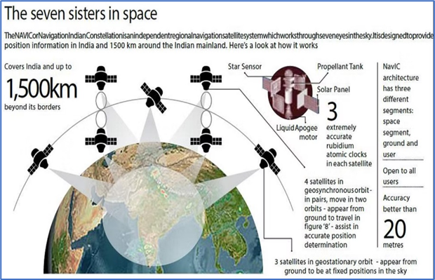
- NavIC, also known as Indian Regional Navigation Satellite System (IRNSS), is an independent stand-alone navigation satellite system developed by ISRO.
- Originally approved in 2006, NavIC was expected to be completed by late 2011, but only became operational in 2018.
- India is promoting the use of NavIC to remove dependence on foreign satellite systems for navigation service requirements, particularly for strategic sectors.
- Relying on systems like GPS and GLONASS may not always be reliable as those are operated by the defence agencies of respective nations.
- Hence, it is possible that civilian services can be degraded or denied.
Features:
- Number of satellites
- NavIC consists of seven active satellites and covers the whole of India’s landmass and up to 1,500 km (930 miles) from its boundaries.
- Three satellites are in geostationary orbit and the remaining four satellites are in geosynchronous orbit.
- A geosynchronous orbit is a high Earth orbit that allows satellites to match Earth's rotation.
- Located at 35,786 kilometers) above Earth's equator, this position is a valuable spot for monitoring weather, communications (including television) and surveillance.
- The geostationary orbit is a special case of the geosynchronous orbit.
- Types of services
- It will provide two types of services:
- Standard Positioning Service (SPS): to all the users.
- Restricted Service (RS): It is an encrypted service provided only to the authorised users.
- Other features
- NavIC signals are designed to provide user position accuracy better than 20m and timing accuracy better than 50ns.
- Usage of NavIC system has increased
- NavIC finds utilisation in national projects like public vehicle safety, power grid synchronisation, real-time train information system and fishermen safety.
- Other upcoming initiatives include:
- common alert protocol-based emergency warning, time dissemination, geodetic network (used for terrestrial surveying) and unmanned aerial vehicles.
- Other than that, many mobile phones available in the country already use chipsets capable of receiving NavIC signals.
Comparison with other navigation satellites
- NavIC SPS signals are interoperable with the other global navigation satellite system signals namely GPS, Glonass, Galileo, and BeiDou.
- However, there is difference in the serviceable area covered by these systems.
- Eg., GPS caters to users across the globe and its satellites circle the earth twice a day, while NavIC is currently for use in India and adjacent areas.
- India’s 2021 satellite navigation draft policy stated the government will work towards expanding the coverage from regional to global to ensure availability of NavIC signal in any part of the world.
- With a fully operational constellation and ground stations outside of India, the system is likely to become more accurate than GPS.
- ISRO plans to set up ground stations in Japan and France to better triangulate the entire area under NavIC coverage.
News Summary
- With an aim to promote the civilian use of NavIC, ISRO is introducing the L1 frequency in all its future satellites.
- The L1 frequency is one of the most commonly used frequencies in the Global Positioning System (GPS).
- There are three civilian GPS frequencies: L1 at 1575.42 MHz, L2 at 1227.60 MHz, and L5 at 1176.45 MHz.
- The L1 frequency will increase the use of the regional navigation system in wearable devices, security systems and personal trackers that use low-power, single-frequency chips.
Key highlights:
- The seven satellites in the NavIC constellation so far use two frequencies for providing positioning data — L5 and S band.
- The new satellites NVS-01 onwards will also have L1 frequency
- The NVS-01 satellite is set to replace one of ISRO’s seven navigational satellites currently in space.

