In News:
- Google has launched a 360-degree interactive panorama feature for 10 Indian cities as part of its Street View services, which is also known as Project Gullify.
- This has been made possible by the new National Geospatial Policy 2021.
- The policy allows local companies to collect this type of data and license it to others, making it the first country where Street View is primarily enabled by partners.
What’s in today’s article:
- About the National Geospatial Policy (NGP) 2021
- News Summary
The National Geospatial Policy (NGP) 2021:
About:
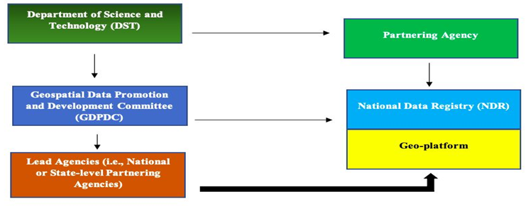
- NGP was launched by the Department of Science and Technology (DST), Ministry of Science and Technology.
- It provides a framework for the DST and its state and central partnering agencies (e.g., government departments, regulatory authorities, etc.) to enable access to and promote the use of geospatial data.
- It aims to boost geospatial entrepreneurship for the socio-economic development of India.
- It also aims to promote the use of geospatial products and services, generate useful insights from geospatial data and strengthen India's geospatial infrastructure and capabilities.
Salient features of the policy:
- Geospatial Data Promotion and Development Committee (GDPDC):
- A multi-disciplinary expert committee to shape the geospatial data ecosystem in India, GDPDC will replace the existing National Spatial Data Committee.
- It will be tasked with working with the Survey of India to create a High Resolution National Topographic Database and will create "Lead Agencies" at the central and state level.
- Functions of Lead Agencies:
- The Lead Agencies will facilitate the implementation of the NGP.
- These Lead Agencies will also provide sector specific knowledge.
- It will assist in the compilation of data themes under the National Foundation Geospatial Data Asset and the National Thematic Geospatial Data Asset.
- National Data Registry (NDR) and Geo-Platform:
- NDR will be operated by the GDPDC, to enable access to and harnessing of geospatial data.
- State and central level partnering agencies can provide data through Data Nodes.
- The geospatial data, metadata and data from the State or central level agencies will be available through a Geo-Platform.
- The GDPDC will designate a Partnering Agency to develop and operate the NDR and Geo-platform under its guidance and supervision.
- Skilled workforce:
- The NGP advocates for surveyor registration in order to promote the profession of surveying, with professional standards and accreditation comparable to that of medical and legal professionals.
- Furthermore, it proposes that the National Skill Development Council and the geospatial industry collaborate to develop a National Skills Qualification Framework and, ultimately, a Geospatial Sector Skill Council.
News Summary:
- About Google Street View:
- In collaboration with Tech Mahindra and Mumbai based Genesys International, Google has launched its 'Street View' experience in India.
- This project was relaunched a decade after it was barred from collecting data for its Street View services.
- Called Project Gullify, Street View will begin in 10 Indian cities (including Bengaluru, Chennai, Delhi, Mumbai, Hyderabad, Pune, etc.).
- From now, it will be available on Google Maps, with new imagery licensed from local partners. The clarity brought about by the new NGP enabled the launch.
- The policy requires that all data be collected by local entities. As a result, the partners are the ones who collect and own the data.
- The policy even specifies areas where data can be collected and which cannot, such as government, defense and military areas.
- Significance:
- Because of its integration with Google Maps, Street View is expected to have a much greater impact, assisting users in better understanding road conditions and discovering local businesses.
- Google Maps has also announced the addition of speed limit data for Bengaluru and Chandigarh, as well as road congestion data for 9 cities.
- It is also developing the environmental insights explorer tool, which will allow planners to better understand how to reduce emissions in cities by measuring emissions based on traffic patterns.
- In a few cities, it will also begin to display localised street-level Air Quality Index (AQI) numbers.
- This data will aid in infrastructure planning and will spark new use cases, such as the creation of base data for autonomous vehicles in India.

