Why in News?
- India’s coastline has increased by nearly 50%, not due to territorial expansion but because of more accurate recent measurements.
- The number of offshore islands has also risen slightly following a reassessment and recount. While these changes hold administrative and strategic significance, they do not reflect any actual change on the ground.
What’s in Today’s Article?
- India’s Coastline Now Measures 11,098 km
- The Coastline Paradox: Why Lengths Keep Changing
- Island Counting: A Different Challenge
India’s Coastline Now Measures 11,098 km
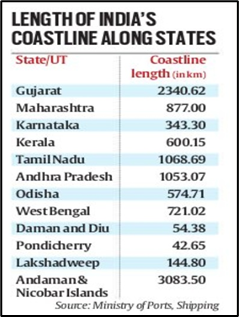
- India’s coastline has increased from 7,516 km to 11,098 km, a rise of 3,582 km (nearly 48%).
- This change is due to improved measurement techniques, not territorial expansion.

- From Low to High-Resolution Mapping
- The previous measurement used low-resolution data (scale 1:4,500,000), which missed fine land features.
- The new measurement used high-resolution data (scale 1:250,000), capturing more bends, curves, and irregularities, thereby increasing the measured length.
- How Scale Affects Measurement
- Using a smaller-scale “ruler” (low resolution) smoothens out intricate details, showing straight lines where bends exist.
- High-resolution tools now map minute variations more precisely, thanks to modern GIS software, replacing older manual methods.
- Inclusion of Offshore Islands
- Another contributor to the increase is the inclusion of many previously uncounted offshore islands, which were either invisible in older data or missed due to manual limitations.
- Significance
- Though the actual land has not changed, the updated coastline data holds strategic and administrative value, improving mapping accuracy and planning for coastal development and security.
The Coastline Paradox: Why Lengths Keep Changing
- India’s new coastline measurement is more accurate but still not definitive.
- This is due to the coastline paradox, which states that irregular natural features like coastlines have no fixed length, as the measured length increases with finer resolution.
- Precision Changes Everything
- The more detailed the measurement (higher resolution), the longer the coastline appears.
- Advancements in mapping technologies, such as GIS, lead to greater precision and thus a longer calculated length.
- The Paradox Beyond Coastlines
- The coastline paradox applies to other natural features too, like river networks and mountain ranges.
- For instance, river banks are irregular, but river lengths are typically calculated along the main stream, avoiding the same variability.
- Periodic Reassessment Now a Norm
- Due to evolving technology and natural processes (like erosion and land reclamation), India has decided to recalculate its coastline every 10 years.
- This aligns with practices in other countries to maintain updated and precise coastal data.
- Implications
- The changing length has administrative, environmental, and strategic relevance, even if it doesn’t reflect a change in physical territory.
- It emphasizes the importance of continuous monitoring and adaptive planning.
Island Counting: A Different Challenge
- Unlike coastlines, island counts don’t face measurement paradoxes, but they do suffer from classification ambiguities—such as whether a landmass submerged at high tide qualifies as an island.
- Previous Discrepancies in Island Numbers
- In 2016, the Surveyor General of India listed 1,382 offshore islands, while state agencies, Coast Guard, and Navy reported a lower count of 1,334.
- The difference arose due to varying definitions and criteria.
- Standardisation and Updated Island Count
- A data reconciliation and standardisation exercise resolved these discrepancies. The final count is:
- 1,298 offshore islands
- 91 inshore islands
- Total: 1,389 islands
- This count excludes river islands like those in Assam and West Bengal.
- Why It Matters
- Standardising island counts has administrative, security, and environmental implications, especially for maritime boundaries, disaster planning, and coastal development.


