Why in News?
- The Indian Space Research Organisation (ISRO) recently released the Landslide Atlas of India, a detailed guide identifying landslide hotspots in the country.
What’s in today’s article?
- About Landslide (Definition, Causes, Classification, India’s Scenario, etc.)
- Landslide Atlas of India (Purpose, Highlights, etc.)
What is a Landslide and what Causes one?
- A landslide is defined as the movement of a mass of rock, debris, or earth down a slope.
- Landslides are a type of "mass wasting," which denotes any down-slope movement of soil and rock under the direct influence of gravity.
- Landslides occur mainly in mountainous terrains where there are conducive conditions of soil, rock, geology and slope.
- Natural Causes that trigger it include heavy rainfall, earthquakes, snow melting and undercutting of slopes due to flooding.
- Landslides can also be caused by Anthropogenic Activities such as excavation, cutting of hills and trees, excessive infrastructure development, and overgrazing by cattle.
- In India, rainfall-induced landslide events are more common.
How are Landslides Classified and Mapped?
- Landslides are broadly classified based on the –

How Prone is India to Landslides?
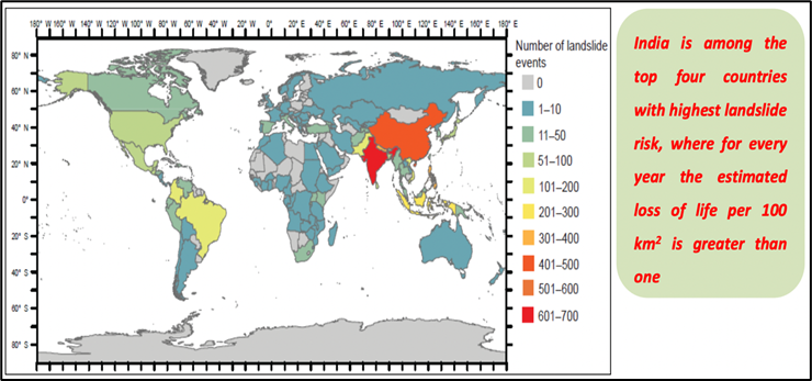
- India is considered among the top five landslide-prone countries in the world.
- In India, at least one death per 100 sq. km is reported in a year due to a landslide event.
- Rainfall variability pattern is the single biggest cause for landslides in the country, with the Himalayas and the Western Ghats remaining highly vulnerable.
- Excluding snow covered areas, approximately 12.6 per cent of the country’s geographical land area (0.42 million sq. km) is prone to landslides.
- As many as 66.5 per cent of the landslides are reported from the North-western Himalayas,
- About 18.8 per cent from the North-eastern Himalayas, and
- About 14.7 per cent from the Western Ghats.
About Landslide Atlas of India:
- The Landslide Atlas of India is prepared by the National Remote Sensing Centre (NRSC).
- NRSC is one of the primary centres of Indian Space Research Organisation (ISRO), Department of Space (DOS).
- NRSC has created a pan-India database of ~80,000 landslides those occurred during last two decades using satellite data.
- This database contains both seasonal landslides and event-based landslides.
- It is a rich collection of landslide inventory which will help user departments in prioritisation of developmental activities in tectonically and ecologically sensitive mountainous areas in India.
What does the Landslide Atlas Suggest?

- Uttarakhand, Kerala, Jammu and Kashmir, Mizoram, Tripura, Nagaland and Arunachal Pradesh reported the highest number of landslides during 1998 – 2022.
- Mizoram topped the list, recording 12,385 landslide events in the past 25 years, of which 8,926 were recorded in 2017 alone.
- Likewise, 2,071 events of the total 2,132 landslides reported in Nagaland during this period occurred during the 2017 monsoon season.
- Manipur, too, showed a similar trend, wherein 4,559 out of 5,494 landslide events were experienced during the rainy season of 2017.
- Of the total 690, Tamil Nadu suffered 603 landslide events in 2018 alone.
- Among all these states, an alarming situation is emerging from Uttarakhand and Kerala.
- Uttarakhand –
- Uttarakhand’s fragility was recently exposed during the land subsidence events reported from Joshimath since January.
- The state has experienced the second highest number (11,219) of landslides since 1998.
- Kerala –
- Kerala has been consistently reporting massive landslides since it suffered the century’s worst floods in 2018.
- The year-wise landslide events here are 2018 (5,191), 2019 (756), 2020 (9) and 2021 (29).
- Most Vulnerable District?
- From the events and images obtained, the NRSC ranked Rudraprayag in Uttarakhand at the top of 147 vulnerable districts.
- It has the highest landslide density in the country, along with having the highest exposure to total population and number of houses.


