Why in news?
- More than 5,000 people are known to have died and thousands more are missing after devastating floods swept through the Libyan port city of Derna.
- Entire neighbourhoods disappeared into the sea as a huge tsunami-like torrent of water swept through the city.
What’s in today’s article?
- Geographical location of Derna
- News Summary
Geographical location of Derna
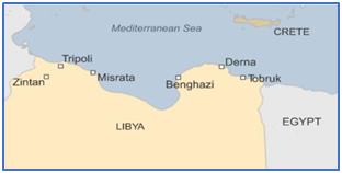
- Derna is a port city in eastern Libya. It is located on the Mediterranean coast between Benghazi and Tobruk.
- It is also located at the eastern end of the Jebel Akhdar, or "green mountains".
- The city is bisected by the Wadi Derna, a seasonal river that flows from the highlands to the south.
News Summary: Libya’s catastrophic flooding
- More than 5,000 people were killed, about 10,000 went missing, and 30,000 were displaced in Libya after torrential rains caused flooding.
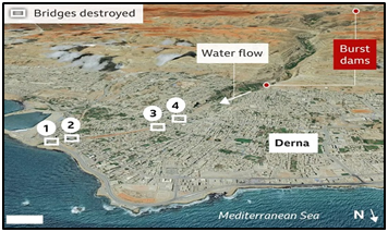
- The flooding burst dams, swept away buildings, and destroyed nearly a quarter of the eastern port city of Derna.
What caused this catastrophic damage to Derna?
- Experts suggest three key factors coalesced into one catastrophe, causing the most devastating floods to have hit North Africa in almost a century.
- These three factors are - extreme weather, vulnerable geography, and crumbling infrastructure.
- Extreme Weather
- Libya’s eastern region, witnessed extreme rainfall from Sept 10 to 11.
- Eg., in Derna, the average monthly rainfall in the whole of September is under 1.5 mm. However, it exceeded 150 mm in about two days.
- The rains were accompanied by strong winds of up to 80 kph.
- The water was brought by Storm Daniel which reached Libya on September 10.
- Formed in Greece, this storm is also responsible for causing floods and deaths in Spain, Turkey and Bulgaria earlier this month.
- Before reaching Libya, Daniel transitioned into what is known as a ‘medicane,’ or tropical-like cyclone that occasionally forms over the Mediterranean Sea.
- The storm became stronger as it drew energy from the abnormally warm waters.
- The Mediterranean has been 2 to 3 degree Celsius warmer this year than in the past.
- Medicanes are known to be weak storms that don’t last long.
- But higher sea surface temperatures help them become stronger and last longer.
- It unloaded excessive rainfall over northeastern Libya, where rain flowing down the mountainous terrain overwhelmed dams.
- Vulnerable geography
- The floods seem to have caused the most destruction in Derna.
- One reason behind the city’s widespread damage is its location.
- It is situated at the end of a valley and bisected by the Wadi Derna, a seasonal river that flows from mountains to the south (towards the sea) and is normally protected from flooding by dams.
- The unusually heavy rain overwhelmed two crucial dams and destroyed several bridges.
- Crumbling infrastructure
- The collapse of the two dams in Derna highlights the dilapidated infrastructure of Libya.
- The country has been gutted by a war between two rival factions for more than a decade.
- In Tripoli, Prime Minister Abdul Hamid Dbeibah leads Libya’s internationally recognised government.
- In Benghazi, the rival prime minister, Ossama Hamad, heads the eastern administration, which is backed by powerful military commander Khalifa Hiftar.
- In the tussle for power, focus on socio-economic issues, including maintaining and developing infrastructure has been put on the backburner.
- Moreover, as flooding is quite rare in the region, Libya wasn’t prepared to face the calamity.
- There are no flood-resilient structures or roads in the country, especially in Derna.
- Any sort of early-warning system regarding such disasters also doesn’t exist.

