Why in News?
- Chinese nationals have started occupying several of their model “Xiaokang” border defence villages across India’s north-eastern borders which the country has been building along the LAC since 2019.
What’s in Today’s Article?
- What is the Line of Actual Control (LAC)?
- Disagreement over the LAC and Why these Claim Lines Controversial in Ladakh
- Recent Developments at the LAC
- Infrastructure Development at the LAC
What is the Line of Actual Control (LAC)?

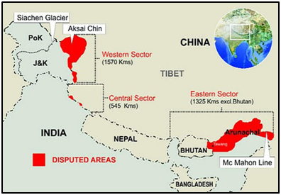
- The LAC is the demarcation that separates Indian-controlled territory from Chinese-controlled territory.
- The LAC is only a concept not agreed upon by the two countries, neither delineated on a map or demarcated on the ground.
- India considers the LAC to be 3,488 km long, while the Chinese consider it to be only around 2,000 km.
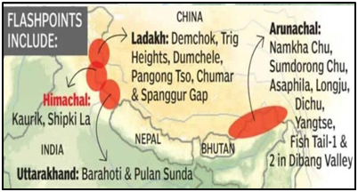
- It is divided into three sectors: the eastern sector which spans Arunachal Pradesh and Sikkim, the middle sector in Uttarakhand and Himachal Pradesh, and the western sector in Ladakh.
- India’s claim line is the line seen in the official boundary marked on the maps as released by the Survey of India, including both Aksai Chin and Gilgit-Baltistan.
- This means LAC is not the claim line for India.
- In China’s case, LAC is the claim line except in the eastern sector, where it claims the entire Arunachal Pradesh as South Tibet.
Disagreement over the LAC and Why these Claim Lines Controversial in Ladakh:

- India rejects the concept of LAC, as it is the line China has created.
- The Chinese line was a disconnected series of points on a map that could be joined up in many ways.
- The line should omit gains from aggression in 1962 and therefore should be based on the actual position on September 8, 1962 before the Chinese attack.
- This vagueness of the Chinese definition left it opens for China to continue its creeping attempt to change facts on the ground by military force. For example, the clash in the Galwan valley between the Indian Army and China's PLA in 2020.
- Aksai Chin in Ladakh province of the princely state of J&K was not part of British India, although it was a part of the British Empire.
- Thus, the eastern boundary was well defined in 1914 (when the Shimla Agreement on the McMahon Line was signed by British India) but in the west in Ladakh, it was not.
- These maps, as is officially used till date, formed the basis of dealings with China, eventually leading to the 1962 War.
Recent Developments at the LAC:
- In the last few months, the Chinese nationals have started occupying a couple of vacant defence villages built on its side of the LAC across from Lohit Valley and the Tawang sector of Arunachal Pradesh.
- China has been constructing 628 such “well-off villages” along India’s borders with the Tibet Autonomous Region, including along Ladakh and Arunachal Pradesh for over five years now.
- While the exact nature of these villages is unclear, the dwellings are understood to be “dual-use infrastructure” - for both civil and military purposes, and seen as a Chinese assertion of its territorial claims along the LAC.
Infrastructure Development at the LAC:
- The Chinese have consistently improved their existing infrastructure (along the LAC) including improving their connectivity through passes, constructing roads and bridges and their model villages.
- China has also been constructing infrastructure, including border villages, in Bhutanese territory.
- In the last three to four years, India has also stepped-up work on its border infrastructure - this includes improving forward connectivity, constructing alternate routes to the LAC as well as connecting them.
- Under the Vibrant Villages programmes, India plans to develop 663 border villages into modern villages with all amenities in the first phase.
- Of them, at least 17 along the borders with China in Ladakh, Himachal Pradesh, Uttarakhand, Sikkim and Arunachal Pradesh, have been selected for development as a pilot project under the programme.
- Also, three major highways are at different stages of construction in Arunachal Pradesh: the Trans-Arunachal Highway; the Frontier Highway; and the East-West Industrial Corridor Highway.


