Why in News?
- The Department of Science and Technology (DST), Government of India, has notified a National Geospatial Policy 2022, with the goal of making India a world leader in the global geospatial sector.
What’s in today’s article:
- What is Geospatial Technology?
- About the National Geospatial Policy, 2022
What is Geospatial Technology?
- Geospatial Technology is an emerging field of study that includes Geographic Information System (GIS), Remote Sensing (RS), and Global Positioning System (GPS).
- It has applications in almost every domain of the economy ranging from -
- Agriculture to industries,
- Development of urban or rural infrastructure,
- Administration of land,
- Economic activities of banking and finance, resources, mining, water, disaster management, social planning, delivery services, etc.
- It enables government systems, services, and initiatives to be integrated using ‘location’ as a common and underpinning reference frame.
- Geospatial data is now widely accepted as a critical national infrastructure and information resource with proven societal, economic and environmental value.
The National Geospatial Policy, 2022:
- Background:
- In 2021, the DST issued “Guidelines for acquiring and producing Geospatial Data and Geospatial Data Services including Maps”.
- The Guidelines deregulated the Geospatial sector by liberalising Geospatial data acquisition/ production/ access, with an aim to promote private sector participation through continued enhancements of Ease of Doing Business in the sector.
- The 2022 Policy takes it further by laying down an overarching framework for holistic development of the Geospatial ecosystem.
- It comes at a time when India's geospatial economy is expected to cross Rs 63,000 crore by 2025 at a growth rate of 12.8%
- About: It is a citizen-centric policy that seeks to strengthen the Geospatial sector to support national development, economic prosperity and a thriving information economy.
- Vision and goals:
- To make India a World Leader in Global Geospatial space with the best in the class ecosystem for innovation.
- To develop a coherent national framework in the country and leverage it to move towards a digital economy and improve services to citizens.
- To develop Geospatial infrastructures, Geospatial skill and knowledge, standards, Geospatial businesses.
- To promote innovation and strengthen the national and sub-national arrangements for generation and management of Geospatial information.
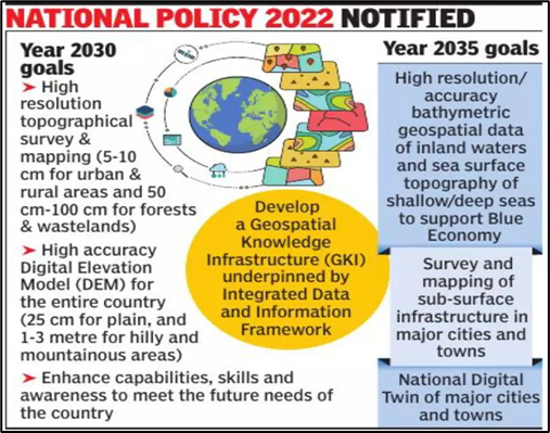
- Following are the milestones (2025, 2030 and 2035) in the journey towards realisation of the aforesaid vision:
- Year 2025: Put in place an enabling policy and legal framework that supports liberalisation of the Geospatial sector and democratisation of data for enhanced commercialization with Value Added Services.
- National Digital Twins of India's major cities and towns by 2035: The digital twin is a virtual replica of a physical asset, process or service that lies at the core of the new digital revolution.
- This facilitates policymakers to understand how infrastructure will function in different situations such as increase of population or during natural disasters.
- Institutional framework:
- A Geospatial Data Promotion and Development Committee (GDPDC, will be a 17-member body) at the national level shall be the apex body for formulating and implementing strategies related to promotion of the Geospatial sector.
- GDPDC would replace and subsume the functions and powers of the National Spatial Data Committee (NSDC) constituted in 2006 and GDPDC constituted in 2021.
- Significance:
- To make geospatial technology and data as agents of transformation for achieving the Sustainable Development Goals (SDGs).
- Bringing efficiency in all sectors of economy and instilling accountability and transparency at all levels of governance.

