Why in News?
- The Indian Space Research Organisation (ISRO) will launch the first of the 2nd-generation satellites for its navigation constellation - NavIC (Navigation with Indian Constellation).
- The 2,232 kg satellite, the heaviest in the constellation, will be launched by a Geosynchronous Satellite Launch Vehicle (GSLV) rocket.
What’s in Today’s Article?
- About NavIC (Navigation with Indian Constellation)
- What is the Advantage of having a Regional Navigation System?
- Old Satellites of NavIC
- What’s New in the 2nd-Generation NavIC Satellite?
About NavIC (Navigation with Indian Constellation):
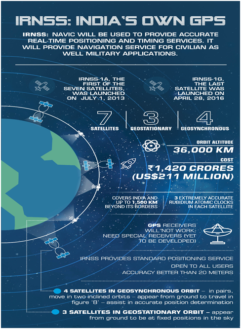
- NavIC, also known as the Indian Regional Navigation Satellite System (IRNSS), is an independent stand-alone indigenous navigation satellite system developed by the Indian Space Research Organisation (ISRO).
- NAVIC was approved in 2006 (at a cost of $174 million) and was expected to be completed by 2011, but only become operational in 2018.
- NavIC, which consists of 7 satellites, covering the whole of India's landmass and up to 1,500 km from its boundaries, is conceived with the aim of removing dependence on foreign satellite systems for navigation, particularly for "strategic sectors.".
- Currently, NavIC's application in India is limited in -
- Public vehicle tracking, for providing emergency warning alerts to fishermen venturing into the deep sea where there is no terrestrial network connectivity and
- For tracking and providing information related to natural disasters.
- The next step India is pushing for is to include it in smartphones.
- According to India's draft satellite navigation policy 2021, the government will work toward "expanding the coverage from regional to global" to ensure the availability of NavIC signals in any part of the world.
What is the Advantage of having a Regional Navigation System?
- India is the only country that has a regional satellite-based navigation system.
- There are four global satellite-based navigation systems - the American GPS, the Russian GLONASS, the European Galileo, and the Chinese Beidou.
- Japan has a four-satellite system that can augment GPS signals over the country, similar to India’s GAGAN (GPS Aided GEO Augmented Navigation).
- With fully operational NavIC (with ground stations outside India [Japan, France, and Russia] for better triangulation of signals) open signals will be accurate up to 5 metres and restricted signals will be more accurate (GPS ~20 metres).
- Unlike GPS, NavIC uses satellites in high geo-stationery orbit - the satellites move at a constant speed relative to Earth, so they are always looking over the same region on Earth.
- NavIC signals come to India at a 90-degree angle, making it easier for them to reach devices located even in congested areas, dense forests, or mountains.
Old Satellites of NavIC:
- Each of the 7 satellites currently in the IRNSS constellation, weighed much less (around 1,425 kg at liftoff) and rode the lighter Polar Satellite Launch Vehicle (PSLV) - ISRO’s workhorse launch rocket.
- The last IRNSS satellite, IRNSS-1I was launched in 2018 to replace an older, partially defunct satellite in the constellation.
- IRNSS-1I was ISRO’s 9th satellite for the NavIC constellation, but is considered to be the 8th because the IRNSS-1H launched in 2017 was lost after the heat shield of the payload failed to open on time.
What’s New in the 2nd-Generation NavIC Satellite?
- The 2nd-generation satellite named as NVS-01, the first of ISRO’s NVS series of payloads is heavier.
- The satellite will have a Rubidium atomic clock onboard, a significant technology (which only a handful of countries possess) developed indigenously by Space Application Centre-Ahmedabad.
- A satellite-based positioning system determines the location of objects by accurately measuring the time it takes for a signal to travel to and back from it using the atomic clocks on board.
- Currently, only four IRNSS satellites are able to provide location services. The other satellites can only be used for messaging services.
- The 2nd generation satellites will send signals in a third frequency, L1, besides the L5 and S frequency signals that the existing satellites provide, increasing interoperability with other satellite-based navigation systems.
- The L1 frequency is among the most commonly used in the GPS, and will increase the use of the regional navigation system in wearable devices and personal trackers that use low-power, single-frequency chips.
- The 2nd-generation satellites will also have a longer mission life of more than 12 years (existing satellites - 10 years).

