In News:
- Nepal Prime Minister, on his visit to India, raised border issue with the Indian Prime Minister.
- However, he agreed not to politicise the border dispute matter.
- Nepal had in the last 2-3 years highly politicized the dispute over the Kalapani area, including passing a new Constitutional Amendment showing this region in Nepal for the first time.
- In this context, we try to under the India-Nepal border dispute over the Kalapani region, and the evolution of the dispute over the recent years.
Background to India-Nepal border dispute at Kalapani region
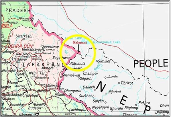
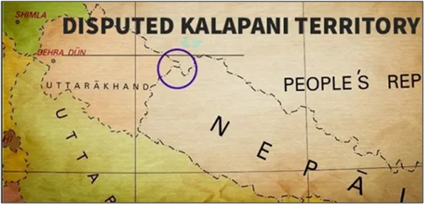
- The border dispute between India and Nepal at Uttarakhand border is over a small triangular shaped region.
- The 3 key areas in this region are Limpiyadhura, Lipulekh and Kalapani that have been with India for a long time.
The 1816 Sugauli Treaty made Kali river as border between India and Nepal:
- The Sugauli Treaty was signed by Nepal with the British in March 1816, when Britain ruled over India.
- As part of the treaty, the British took back the Kumaon and Garhwal regions that were earlier annexed by the Nepali Gurkha kings.
- Under the treaty, Nepal renounced all claims to the areas lying to the west of river Kali (at the border of Uttarakhand and Nepal).
- The land east of river Kali thus remained with Nepal.
- This claim is reinforced by some old revenue records and gazette notifications.
- The treaty underwent some revisions to accommodate Nepal in the Terai (southern part) and was finally endorsed by the British government on November 15, 1860.
India accepts this position:
- India accepts this position, that the land east of the Kali is with Nepal, and to the west is with India.
- British handed over Kalapani to India at the time of independence.
Dispute is over the uncertainty regarding the origin of Kali river:
- There is ambiguity in the Sugauli treaty on the identification of the Kali river and its origin.
- For India, it originates at Lipu Lekh:
- According to India, the river originates from Lipu Lekh and then merges into other streams and tributaries to become the Mahakali.
- Consequently, Limpiyadhura, Lipulekh and Kalapani lie to the west of river Kali and thus part of India.
- For Nepal, it originates at Limpiyadhura:
- Nepal’s contention is that Kali originates from Limpiyadhura and the stream originating from Lipu Lekh is called Lipu Khola.
- Thus, as per Nepal, Limpiyadhura, Lipulekh and Kalapani lie to the east of river Kali and thus become a part of Nepal.
- Kalapani is the area between the two claims:
- The area between these two streams is Kalapani.
- This is the basis of the dispute over the Kalapani region.
Till 2020, Nepal also endorsed India's position on this:
- Nepal has endorsed India’s position for nearly 150 years.
- It used Indian maps showing Kalapani, Limpiyadhura and Lipu Lekh in India.
China has also accepted India's position:
- China accepted Lipu Lekh as one of the cultural and commercial transit points with India under its 1954 Peaceful Co-Existence Agreement.
- This was reiterated in 2015 in a joint statement during Prime Minister Narendra Modi’s visit to China.
Significance of Lipulekh/ Kalapani to India:
- Historical and Cultural:
- Kalapani has historical, spiritual and cultural significance for India due to its location on the trade and pilgrim route to Tibet.
- Much before the British came, Indians were using this route (via kumaon in Uttarakhand to Lipu Lekh pass) for the pilgrimage to Kailash Mansarovar.
- Even Nepal acknowledged this old trade route be a major node for India-China trade (Lipulekh is at India-China-Nepal trijunction).
- Strategic:
- The high Lipulekh mountain pass in Kalapani is currently also of strategic interest to India.
- It helps India track Chinese movements in the region.
- Since 1962, it's been manned by the Indo-Tibetan Border Police.
Recent events surrounding Kalapani
India published map showing Kalapani in India in 2019 (similar to earlier):
- The dispute was triggered in November 2019 when India issued a new map to indicate the changed status of Jammu and Kashmir into a Union Territory.
- Nepal raised objections because the Kalapani area was shown as being in India.
- Indian maps have always shown it that way; therefore, there was no change in the map in this area.
- Map published by India:
India inaugurated road to Lipu Lekh Pass in 2020:
- In May 2020, India inaugurated a road from Darchula to Lipu Lekh Pass, aimed at strengthening India’s defence supply lines as well as facilitating smooth passage for pilgrims to Kailash Mansarovar in Tibet.
- Nepal’s objected to it, saying the road is an encroachment on its sovereignty.
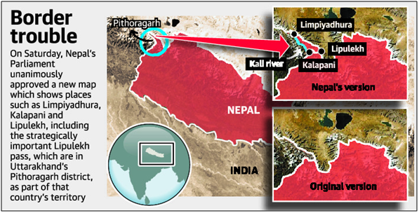
In 2020, Nepal amended its constitution to show Kalapani in Nepal for the first time
- In June 2020, Nepal's Parliament made a constitutional amendment to update its national emblem by incorporating Limpiyadhura, Lipulekh and Kalapani.
- This was an effort to give legal status in that country for the new political map of Nepal to include the Kalapani region.
- India rejected Nepal’s claim saying the region lies completely within Indian borders.
- Map as per Nepal after this amendment:
- India then told Nepal it would refuse to hold boundary talks after the passage of this amendment, as it violated the understanding that talks should sort out boundary issues.