Context
- As cracks on walls and buildings have recently been discovered, land subsidence (ground sinking) in Joshimath, Uttarakhand, has generated alarm and protests among the local population.
- The subsidence has been increasing at an alarming rate in recent days, and it is building up to be the second big turning point in Uttarakhand's history, following the tragic Kedarnath floods of 2013.
- The article examines the causes of the recent incidents of land subsidence in Joshimath, and preventive measures that are required to handle the situation.
About land subsidence
- It is a gradual settling or sudden sinking of the earth’s surface often caused by the removal of water, oil, natural gas, or mineral resources out of the ground by pumping, fracking, or mining activities.
- It can also be caused by natural events such as earthquakes, soil compaction, glacial isostatic adjustment, erosion, sinkhole formation, etc.
- The Uttarakhand government's expert panel in 2022 found several pockets of Joshimath "sinking" due to the removal or displacement of subsurface materials that has induced structural defects and damage in the town.
Reasons Behind Recent Joshimath Catastrophe
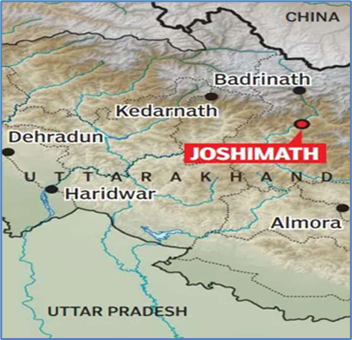
- Location: Joshimath/ Jyotirmath is a hilly town in Chamoli District in the Indian state of Uttarakhand, located on the Rishikesh-Badrinath National Highway (NH-7) at a height of 6150 feet (1875 m).
- Topography: Joshimath is situated in the middle slopes of a hill bounded by the Karmanasa and Dhaknala streams on the west and the east and the Dhauliganga and Alaknanda rivers on the south and the north undercut the town making it even more prone to disasters.
- Also, a study by Uttarakhand State Disaster Management Authority (USDMA) in 2022 found that perennial streams, appreciable snow in the upper reaches and highly weathered gneissic rocks with low cohesive characteristics makes the area prone to landslides.
- Geology: According to the Mishra Committee Report (1976), Joshimath is being built on a fragile mountain slope that have deposits of sand and stone, the remnants of ancient landslides triggered by earthquakes, thus not suitable for a township.
- The town also sits on a tectonic fault line and falls in Zone V of the Seismic Zonation Map and has witnessed several earthquakes over decades.
- This has made the town highly vulnerable to sinking because of tectonic activity.
- Unplanned development: As per USDMA survey report in 2022, unplanned developmental activities without due regard to bearing capacity have contributed in aggravating slope instability-related issues in Joshimath.
- Over time, layers upon layers of new construction, rapid urbanization coupled with deforestation have weakened the foundation in the already fragile area.
- Improper water drainage: USDMA has pointed out that inadequate drainage and wastewater disposal systems in Joshimath have exacerbated ground subsidence.
- Firstly, on-surface anthropogenic activities block the natural water flow that then percolates down into the porous crystalline rocks beneath the surface, and put pressure in the form of tectonic forces softening them further.
- Secondly, the existence of soak pits instead of proper drainage allows water to slowly leak into the ground, creating cavities between the soil and the boulders leading to water seepage and soil erosion.
- This reduces the shear strength of the overburden soil and pushes down lose material into the ground, resulting in land sinking.
- Unsustainable tourism: High footfall by tourists heading to shrines like Badrinath, Hemkund Sahib and Adi Shankaracharya temple has resulted in the construction of hotels and marketplace in the ecologically sensitive zone, aggravating the subsidence.
- Heavy construction: All-weather road (Helang bypass) to reduce the distance to Badrinath shrine by about 30 km, using heavy machinery is being built by Border Roads Organisation (BRO) that is believed to have disturbed the Joshimath’s mountain foundation.
- Hydroelectric projects: The 520 MW Tapovan Vishnugad Hydro Power plant on the Dhauliganga river led to the construction of a tunnel that cut through the mountain upon which Joshimath is located.
- This led to hollowing of the ground beneath the town initiating subsidence in the region.
- Impact of earlier disasters: The region might be continuing to experience the release of energy from the 1999 Chamoli earthquake.
- Also, the floods in the Rishiganga and Dhauliganga rivers in 2021 is likely to have impacted the stability of the slope on which Joshimath town is situated.
- Administration turning a blind eye towards the fragile ecology: For example, a High-Powered committee (HPC) on the Char Dham Project raised concerns about the geological vulnerability of the area and sanctioning of hydroelectric projects in the Joshimath, but no remedial measures were taken by the authorities.
- Climate change impact: Uttarakhand being already vulnerable to natural disasters, the impact of climate change in terms of extreme weather events like cloudburst, flash flood, landslides, or glacial outburst could be very dangerous for the hilly state.
- For instance, due to extreme rainfall the mountain streams have expanded their channels and changed course, thereby inducing more slope instability in already fragile belt.
Steps Taken by the State Government to Avert the Crises
- The government has declared Joshimath town a landslide-subsidence zone.
- The construction of the NTPC Hydro Power Plant and the Helang Bypass has been stopped till further orders and technical resources from nearby areas have been summoned to Joshimath to find a solution.
- Evacuation plans are in the works and the government has put in an order for 4,000 prefabricated homes to help the residents of Joshimath.
- The government is also planning to set up micro-seismic observation systems in Joshimath that would generate risk resilient parameters for safer dwellings and infrastructure.
Way Forward
- The Mishra Committee: It had recommended decades ago to ban on heavy construction in the area around Joshimath.
- ‘Whole of government’ approach: An inter-disciplinary investigation of the affected area to contain the situation, and undertaking continuous seismic monitoring by Geological Survey of India (GSI) could help avert the damage to a large extent.
- Also, other central institutions like the National Institute of Hydrology (NIH), NDMA, IIT Roorkee, Central Building Research Institute (CBRI), etc., should work closely with the state of Uttarakhand in the spirit of ‘whole of government’ approach.
- A time-bound reconstruction plan: This includes developing a risk sensitive urban development plan that could help in long-term solution to the crises.
- Information dissemination: The state government should establish a clear and continuous communication channel with the residents to prevent scare and chaos.
- Monitoring: The Union Earth Sciences Ministry should monitor seismic activity and natural disasters across Joshimath on a regular basis. It will also augment micro-zonation of such areas and increase mapping.
Conclusion
- To save Joshimath, the government and civil bodies must work together, with the assistance of military organisations such as the Border Roads Organisation (BRO) and make sweeping changes in planning and development path to ensure survival of the fragile ecosystem.

