Why in news?
Wayanad, currently reeling from the deadly July 30 landslide disaster, was among several places in Kerala identified by the ISRO in 2023 as being highly susceptible to landslides based on key socio-economic parameters.
In the Landslide Atlas of India, prepared by the National Remote Sensing Centre (a unit of ISRO) in February 2023, Wayanad ranked 13th among 147 districts across 17 States and two Union Territories.
Meanwhile, Thrissur, Palakkad, Malappuram, and Kozhikode ranked third, fifth, seventh, and tenth, respectively.
What’s in today’s article?
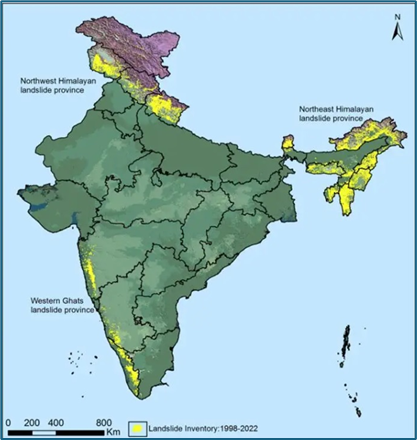
Landslide Atlas of India
- About
- The Landslide Atlas of India, prepared by the National Remote Sensing Centre (NRSC) of ISRO, details landslide occurrences and damage assessments in landslide-prone areas of India.
- It covers 147 districts in 17 states and two Union Territories in the Himalayas and Western Ghats.
- The geospatial landslide inventory database includes approximately 80,000 landslides mapped from 1998 to 2022, categorized into three types: seasonal, event-based, and route-wise inventories.
- The seasonal inventory documents landslides from the 2014 and 2017 rainy seasons.
- The event-based inventory includes major events like the Kedarnath and Kerala disasters and the Sikkim earthquake.
- The route-wise inventory covers landslides along significant tourist and pilgrimage routes.
- The mapping utilized high to very high-resolution satellite data, including IRS-1D, Resourcesat, Cartosat, Sentinel, Pleiades, and WorldView, as well as aerial images, with some landslides validated in the field.
- The data was used to rank districts based on their exposure to landslides, considering key socio-economic parameters.
- Key findings
- Uttarakhand, Kerala, Jammu and Kashmir, Mizoram, Tripura, Nagaland and Arunachal Pradesh reported the highest number of landslides during 1998 – 2022.
- Mizoram topped the list, recording 12,385 landslide events in the past 25 years, of which 8,926 were recorded in 2017 alone.
- Likewise, 2,071 events of the total 2,132 landslides reported in Nagaland during this period occurred during the 2017 monsoon season.
- Manipur, too, showed a similar trend, wherein 4,559 out of 5,494 landslide events were experienced during the rainy season of 2017.
- Among all these states, an alarming situation is emerging from Uttarakhand and Kerala.
- Uttarakhand
- Uttarakhand’s fragility was recently exposed during the land subsidence events reported from Joshimath since January.
- The state has experienced the second highest number (11,219) of landslides since 1998.
- Kerala
- Kerala has been consistently reporting massive landslides since it suffered the century’s worst floods in 2018.
- The year-wise landslide events here are 2018 (5,191), 2019 (756), 2020 (9) and 2021 (29).
- Most Vulnerable District
- From the events and images obtained, the NRSC ranked Rudraprayag in Uttarakhand at the top of 147 vulnerable districts.
- It has the highest landslide density in the country, along with having the highest exposure to total population and number of houses.

