Why in News?
- Due to land subsidence, roads and over 560 houses in Joshimath - a key transit point for tourists travelling to Badrinath and Hemkund Sahib - developed cracks, causing panic and protests among the local population.
- Officials said the disaster management department is conducting surveys at locations where new cracks have developed.
What’s in today’s article?
- Where is Joshimath located?
- Why is Joshimath sinking?
- What can be done to save Joshimath?
Where is Joshimath located?

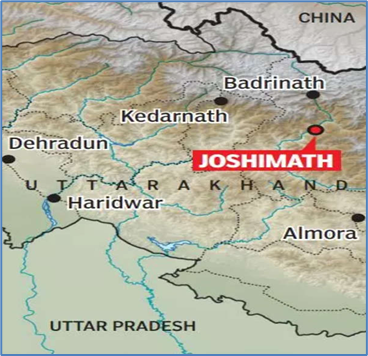
- Joshimath/ Jyotirmath is a hilly town in Chamoli District in the Indian state of Uttarakhand, located on the Rishikesh-Badrinath National Highway (NH-7) at a height of 6150 feet (1875 m).
- The town (fall in high-risk seismic Zone-V) is traversed by running streams with a high gradient from Vishnuprayag, a confluence of the Dhauliganga and the Alaknanda rivers.
- It is a gateway to several Himalayan Mountain climbing expeditions, trekking trails (Auli, Valley of Flowers) and pilgrim centres like Badrinath and Hemkund Sahib.
- Joshimath is also of great strategic importance to the Indian armed forces and is home to one of the Army's most important cantonments.
- It is home to one of the four cardinal maths or monasteries established by Adi Shankara - Sringeri in Karnataka, Dwarka in Gujarat, Puri in Odisha and Joshimath near Badrinath in Uttarakhand.
- A 2022 report (by the Wadia Institute of Himalayan Geology) stated that the area around Joshimath is covered with thick layers of overburdened material.
Why is Joshimath sinking?
- Joshimath is located on the site of an ancient landslide: This was found in a 1976 report (by government-appointed Mishra Commission), meaning scientists and geologists working in the area have been sounding the alarm for decades.
- Geography of the town: Scattered rocks in the area are covered with old landslide debris comprising boulders, gneissic rocks (highly weathered), and loose soil (due to seepage from streams uphill), with a low bearing capacity.
- High rate of construction: Increased construction, hydroelectric projects, and the widening of the NH have made the slopes highly unstable in the last couple of decades.
- Erosion: Due to the running streams from Vishnuprayag and sliding along the natural streams are the other reasons behind the city's fate.
- The Rishi Ganga flood disaster: This has worsened the situation, followed by incessant rainfall between August to October in 2021.
What can be done to save Joshimath?
- The urgent need is to relocate the residents to a safer place and then reimagine the town's planning to accommodate the new variables and the changing geographical factors.
- Drainage and sewer planning (as more and more waste is seeping into the soil, loosening it from within) is one of the biggest factors that needs to be studied and redeveloped.
- Experts recommend a complete shutdown of development and hydroelectric projects in the region.
- Experts have also suggested replantation in the region, especially at the vulnerable sites to retain soil capacity.
- There is a need for a coordinated effort between the government and civil bodies with the aid of military organisations like the Border Roads Organisation (BRO) to save Joshimath.
- A sufficient number of National Disaster Response Force (NDRF) and State DRF teams should be deployed and helicopter facilities should be provided, if required.


