March 31, 2025
Prelims Pointers
March 31, 2025
Why in the News?
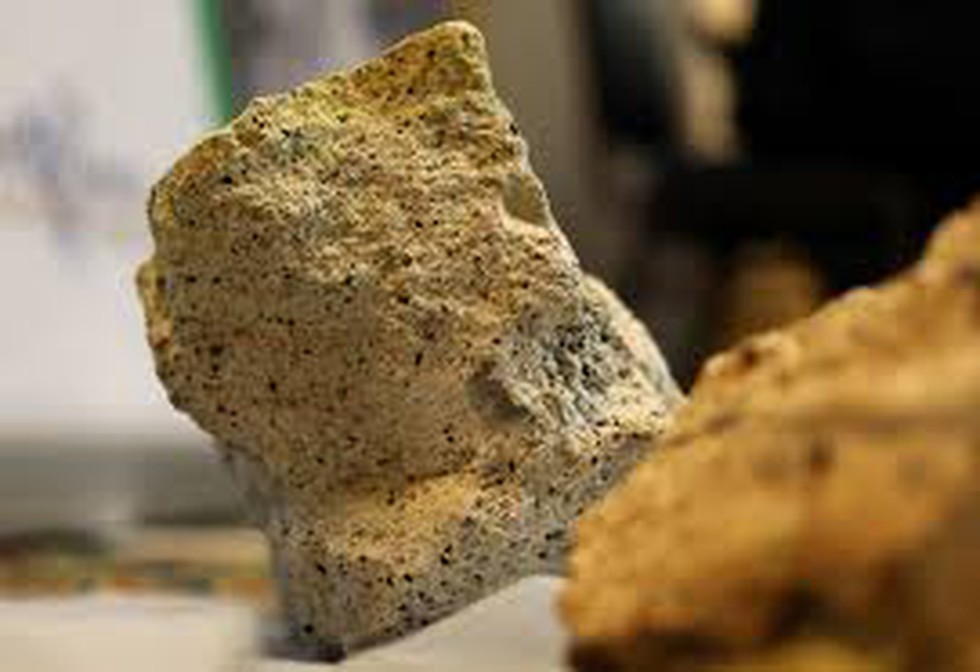
- Centrifuges play a crucial role in uranium enrichment, which is necessary for nuclear power generation and weapons development.
- Natural uranium contains 3% U-238 and only 0.7% U-235. Since only U-235 is fissile, it must be enriched for use in reactors and weapons.
- Nuclear power reactors require uranium with 3-20% U-235, while nuclear weapons need 90% enrichment.
- Iran’s uranium enrichment program has drawn global attention, with thousands of advanced centrifuges being deployed.
What is a Centrifuge?
- A centrifuge is a device that separates substances based on density using centrifugal force.
- Used extensively in scientific research, medical applications, and nuclear technology.
How Centrifuges work in Uranium Enrichment
- Uranium conversion: Uranium is converted into uranium hexafluoride (UF₆)
- Centrifugation process: UF₆ gas is introduced into high-speed centrifuges spinning at 50,000 RPM (revolutions per minute).
- Heavier U-238 isotopes move outward, while lighter U-235 isotopes concentrate towards the center.
- Gradual Enrichment: The U-235-rich fraction is transferred to additional centrifuges to increase purity further.
- Over multiple separation stages, uranium is enriched to the desired levels.
Key Components of a Centrifuge
- Rotor: The spinning component that creates centrifugal force.
- Chamber: Holds the uranium gas for separation.
- Material: Typically made of carbon fiber or other lightweight yet strong materials to withstand high speeds.
Prelims Pointers
March 31, 2025
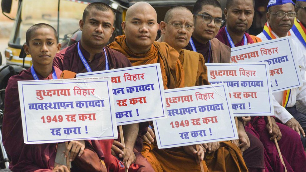
What is the Bodh Gaya Temple Act (BTA), 1949?
- The Act established an eight-member management committee to oversee the temple.
- Equal representation was given to Hindus and Buddhists, but the District Magistrate (DM) was made the ex-officio chairperson.
- Since the DM historically came from the Hindu community, this created a perceived Hindu majority in temple administration.
- Buddhist organizations have long demanded full control over the temple, calling it Bodh Gaya Mahavihara.
Historical Background of the Dispute
- Ancient Period: Emperor Ashoka built the original temple at Bodh Gaya in the 3rd century BCE. It remained a Buddhist religious center until the Pala dynasty.
- Medieval Period (13th Century):
- Bakhtiyar Khilji’s invasion led to the decline of Buddhism in India.
- 1590: A Hindu monk established the Bodh Gaya Mutt, leading to Hindu control over the temple.
- Colonial Period: British-era records refer to Bodh Gaya as a Hindu-controlled site.
- Post-Independence (1949): The Bihar Assembly passed the BTA to formalize temple management, transferring control to the new committee instead of a single Hindu authority.
Government Interventions
- The BTA, 1949, was passed to resolve ongoing disputes between Hindu and Buddhist religious heads.
- 2013 Amendment: The Bihar government amended the rule, allowing the ex-officio chairman (DM) to be from any faith.
- Early 1990s: Bihar CM Lalu Prasad Yadav drafted the Bodh Gaya Mahavihara Bill, aiming to transfer temple management to the Buddhist community.
- The Bill prohibited Hindu idol immersions near the temple and Hindu marriages inside the premises.
- However, it was never passed and remains in cold storage.
About the Mahabodhi Temple Complex
- The Bodh Gaya Temple is one of the four most sacred sites of Buddhism, marking the location where Buddha attained Enlightenment (Bodhi) along with:
- Lumbini (Buddha’s birthplace)
- Sarnath (Buddha’s first sermon)
- Kushinagar (Buddha’s parinirvana
- Location: Bodh Gaya, Bihar, on the banks of the Niranjana River.
- The temple is one of the oldest surviving brick structures in India.
- Originally built by Ashoka in the 3rd century BCE, the present structure dates to the 5th–6th centuries CE.
- UNESCO World Heritage Site since 2002.
Architectural Features
- Grand Temple: A 50-meter-high pyramidal shikhara (tower) with intricate engravings and arch motifs.
- Four smaller towers, each topped with an umbrella-like dome, surround the central temple.
- Sacred Bodhi Tree: Believed to be a direct descendant of the original tree under which Buddha attained Enlightenment.
- Vajrasana (Diamond Throne): A stone slab marking the exact spot where Buddha meditated.
- Temple Shrine: Houses a yellow sandstone statue of Buddha, encased in glass.
- The 8-hectare complex includes ancient shrines and modern Buddhist structures built by devotees.
Prelims Pointers
March 31, 2025
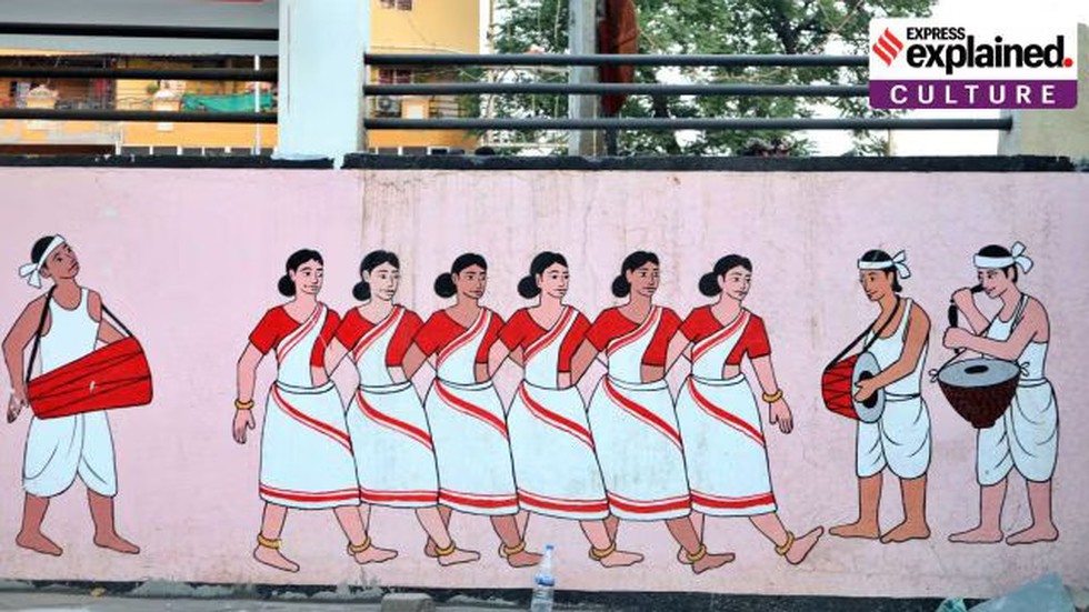
What is Sarhul?
- Meaning: Sarhul means “worship of the Sal tree” and signifies the union of the Sun and the Earth, which is essential for life.
- Nature worship: The Sal tree is considered sacred, believed to be the abode of Sarna Maa, the village deity.
- Three-Day Festival:
- Day 1 – Preparations begin, with homes and Sarna Sthals cleaned, Sal flowers gathered, and the village priest (pahan) observing a strict fast.
- Day 2 – Main rituals are performed at Sarna Sthals (Sacred Groves), including sacrifices, prayers for prosperity, and cultural performances.
- Day 3 – Concludes with a community feast, featuring Handia (rice beer), ceremonial fishing, and traditional adivasi cuisine.
- Sarhul across regions:
- The festival is celebrated by several tribes, including the Oraon, Munda, Santal, Khadia, and Ho.
- Anthropologist Sarat Chandra Roy (1928) noted that Sarhul evolved from a hunting-based ritual to an agricultural festival, reflecting changes in adivasi life.
- Due to historical migration, Sarhul is now celebrated in Assam, Andaman and Nicobar Islands, Nepal, Bangladesh, and Bhutan.
Political Significance
- 1960s: Baba Karthik Oraon, an adivasi leader advocating for tribal rights and cultural preservation, initiated a Sarhul procession in Ranchi.
- Modern Processions: Over the last 60 years, Sarhul processions have become larger, with Siram Toli Sarna Sthal in Ranchi becoming a focal point.
- Assertion of Tribal Identity:
- Adivasi communities use the festival to reaffirm their distinct identity.
- Some groups demand official recognition of the Sarna religion in India's caste census.
- Others, influenced by Hindu organizations, argue that Adivasis are part of Sanatan Dharma (Hinduism).
What Are Sacred Groves?
- Sacred Groves are small forest patches protected by local communities due to their religious and cultural
- These groves serve as biodiversity hotspots, preserving rare plant and animal species.
- Human activities such as hunting and deforestation are restricted, while sustainable practices like honey collection and deadwood gathering are permitted.
Sacred Groves Across India
|
Region |
Local Name |
|
Jharkhand, Bihar |
Sarna |
|
Himachal Pradesh |
Dev Van |
|
Karnataka |
Devarakadu |
|
Kerala |
Kavu or Sarpa Kavu |
|
Maharashtra |
Devrai or Deorai |
|
Meghalaya |
Law Kyntang or Asong Khosi |
|
Rajasthan |
Oran |
- Successful Example: Piplantri village, Rajasthan
- Unique Initiative: 111 trees planted for every girl child born.
- Impact: Boosted local income, reduced female feticide, and empowered women’s self-help groups.
Prelims Pointers
March 31, 2025
Why in the News?
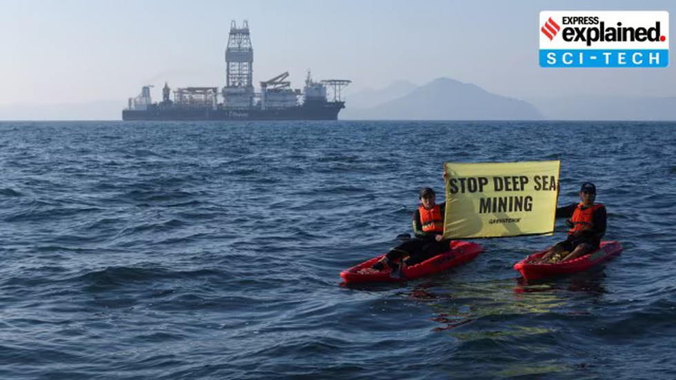
- The study, conducted by Britain’s National Oceanography Centre, found long-term sediment changes and a decline in populations of larger organisms in the mined area.
- This comes amid growing global calls for a moratorium on deep sea mining, with 36 countries recently discussing the issue at a United Nations International Seabed Authority meeting in Jamaica.
What is Deep Sea Mining?
Deep sea mining involves the extraction of mineral deposits and metals from the ocean seabed. It is categorized into three types:
|
Type of Deep Sea Mining |
Process |
Key Minerals Extracted |
|
Polymetallic Nodule Mining |
Collecting mineral-rich nodules from the ocean floor |
Nickel, Cobalt, Rare Earths |
|
Seafloor Massive Sulphide Mining |
Extracting metal deposits from hydrothermal vents |
Gold, Silver, Copper, Zinc |
|
Cobalt-Rich Crust Mining |
Stripping cobalt crusts from underwater mountains |
Cobalt, Platinum, Manganese |
- These minerals are crucial for battery production, renewable energy technologies, and electronics like mobile phones and computers.
- Mining technology is still evolving, with companies developing:
- Massive pumps to vacuum materials from the seabed
- AI-based deep-sea robots to extract nodules
- Advanced machinery for mining near underwater mountains and volcanoes
- Governments and corporations view deep sea mining as a strategic necessity due to depleting onshore reserves and increasing demand for critical minerals.
International Seabed Authority (ISA)
About ISA
- Established under the 1982 United Nations Convention on the Law of the Sea (UNCLOS).
- Came into force in 1994 and became fully operational in 1996.
- Headquarters – Kingston, Jamaica.
Functions of ISA
- Regulates and manages mineral-related activities in international seabed areas beyond national jurisdiction.
- Grants licenses for deep-sea exploration and mining.
- Ensures environmental protection while overseeing resource utilization.
- ISA recently held a council meeting with 36 countries to discuss whether mining companies should be allowed to extract minerals from the ocean floor.
Prelims Pointers
March 31, 2025

What is Green Credit (GC)?
- Green Credit (GC) is a unit of incentive provided for engaging in environmentally positive activities.
- These credits can be traded on a dedicated exchange, similar to carbon credits.
- The Green Credit Programme (GCP) operates under the Environment (Protection) Act, 1986.
Green Credit vs Carbon Credit
|
Feature |
Green Credit (GC) |
Carbon Credit (CC) |
|
Governing law |
Environment (Protection) Act, 1986 |
Energy Conservation Act, 2001 |
|
Beneficiaries |
Individuals, communities, private industries |
Primarily industries and corporations |
|
Objective |
Encourages environment-friendly actions like afforestation, water conservation, and sustainable agriculture |
Focuses on reducing carbon emissions by setting emission limits |
|
Market mechanism |
Can be traded on a domestic exchange |
Traded in national & international carbon markets |
|
Climate co-benefits |
May qualify for carbon credits, leading to reduced carbon emissions |
Cannot be converted into Green Credits |
Implementation of the Green Credit Programme (GCP)
- The Environment Ministry launched the Green Credit Programme (GCP) to enhance forest cover, promote sustainable practices, and incentivize pro-environmental actions.
- Who can earn Green Credits?
- Individuals, communities, and industries that engage in eco-friendly activities.
- Examples include:
- Afforestation & reforestation
- Water conservation
- Sustainable agriculture
- How does it work?
- Participants receive tradable Green Credits for their contributions.
- These credits can be sold to industries that need to fulfill environmental obligations (e.g., compensatory afforestation).
- Green credits can be traded on a domestic platform, enabling entities to meet their legal obligations, such as compensatory afforestation for industrial projects.
Since its launch, 384 entities, including 41 Public Sector Undertakings (PSUs) like Indian Oil Corporation Ltd, Power Grid Corporation of India Ltd, and NTPC Ltd, have registered under the scheme
Prelims Pointers
March 31, 2025

About Karimpuzha Wildlife Sanctuary:
- It lies in the Malappuram district in Kerala.
- Spanning approximately 227.97 sq.km, the sanctuary is situated on the western slopes of the Nilgiri Hills.
- The forest areas of Karimpuzha WLS forms part of the Nilgiri Biosphere Reserve (NBR), recognized under the Man and Biosphere Programme of UNESCO.
- Karimpuzha WLS shares a boundary with Mukurthi NP (Tamil Nadu) on the eastern side and Silent Valley NP (Kerala) on the southern side.
- The name ‘Karimpuzha’ is derived from the Karimpuzha River, a tributary of the River Chaliyar.
- The sharp topographical gradient of the hills ranging from 40 m to 2550 m is the primary reason for the unique biodiversity of the Karimpuzha WildLife Sanctuary.
- The area merges with landscapes of Tamil Nadu and Kerala.
- Steep hills, deep valleys, marshy lands, grasslands, and shola forests with hillocks, and perennial water sources combined with altitudinal variations make it an ideal habitat for a variety of flora and fauna.
- The nomadic tribe cholanaikans, cavemen of Kerala, are living inside the Karimpuzha WLS.
- They are classified as Particularly Vulnerable Tribal Groups (PVTGs) by the Government of India.
- Flora: It is the state’s only forest stretch where seven forest types found in the state are all present, including evergreen rainforest, semi-evergreen forest, moist deciduous forest, sub-tropical hill forest, sub-tropical savannah, montane wet temperate forest and montane wet grasslands.
- Fauna: It is home to a variety of fauna endemic to the Western Ghats, including the Nilgiri Tahr, Lion-tailed macaque, slender loris, tiger, gaur.
Prelims Pointers
March 31, 2025

About International Federation of Red Cross and Red Crescent Societies (IFRC):
- It is the world’s largest humanitarian network.
- Founded in 1919, the Geneva-based Federation brings together 192 Red Cross and Red Crescent societies and some 100 million volunteers.
- The IFRC’s mission is to improve the situation of the most vulnerable, coordinating emergency international assistance to people affected by natural and man-made disasters, including the forcibly displaced, and in health crises.
- The Federation also helps vulnerable communities to overcome crisis and become more resilient through disaster preparedness activities.
- Its mandate includes strengthening the capacities of its member Red Cross and Red Crescent Societies to conduct effective emergency relief, disaster preparedness, and health and community care programmes.
- It also represents these societies at an international level.
- The IFRC also has programs addressing the humanitarian consequences of rapid urbanization, climate change, violence and migration.
- Funding: Voluntary contributions from governments, NGOs, corporate donors, and the public.
- Relationship with ICRC: Works alongside the International Committee of the Red Cross (ICRC), which focuses on humanitarian law and aid in conflict zones.
Prelims Pointers
March 31, 2025

About Tonga:
- Tonga, officially the Kingdom of Tonga, also called Friendly Islands, is an archipelago composed of 169 islands, of which only 36 islands are inhabited, and is located in the South Pacific Ocean.
- It lies south of Samoa, east of Fiji, and just north of the Tropic of Capricorn.
- Tonga’s western islands are volcanic (four with active volcanoes) and sit well above sea level. Those to the east are coral and are more low-lying.
- The three largest islands are Tongatapu, Ha'apai, and Vava'u, with Tongatapu being the most populated.
- The capital, Nuku‘alofa, is on the island of Tongatapu.
- Due to its location within the Pacific Ring of Fire, Tonga experiences relatively frequent volcanic activity.
- A former British protectorate, Tonga became fully independent in 1970, although it was never formally colonised.
- Political System: It is a constitutional monarchy.
- Tonga is a member of the Commonwealth and of the United Nations.
- Language: Tongan, English
- Currency: Tongan Paʻanga (TOP)
- Economy: Tonga has no strategic or mineral resources, and relies on agriculture, fishing and the money sent home by Tongans living abroad.
Prelims Pointers
March 31, 2025
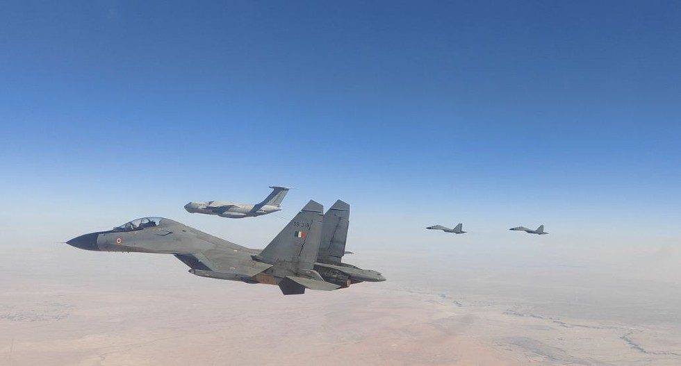
About INIOCHOS:
- It is a biennial multinational air exercise hosted by Greece's Hellenic Air Force.
- It serves as a platform for air forces to hone their skills, exchange tactical knowledge, and strengthen military ties.
- INIOCHOS-25:
- It will take place at Andravida Air Base in the region of Elis, Greece.
- It will integrate multiple air and surface assets from fifteen countries under realistic combat scenarios, designed to simulate modern-day air warfare challenges.
- The IAF contingent will include Su-30 MKI fighters, along with combat-enabling IL-78 and C-17
- Apart from the Hellenic Air Force and the IAF, the participants include France with the M-2000, Israel with G-550, Italy with Tornado, Montenegro with B-412, Poland with F-16, Qatar with F-15, Slovenia with 2 PC-9, Spain with F-18, the UAE with M-2000/9, and the US with F-16, KC-46, and KC-135.
- It will provide an opportunity to train in planning and executing combined air operations, refine tactics in complex air warfare scenarios, and gain insights into operational best practices.
Prelims Pointers
March 31, 2025
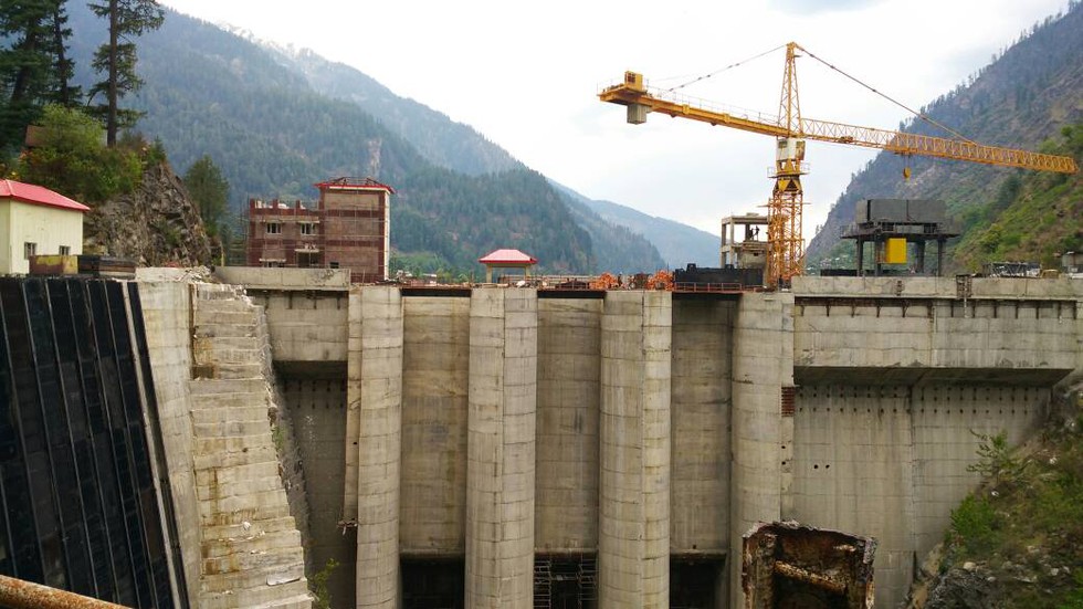
About Parbati-II Hydroelectric Project:
- The Parbati Hydroelectric Project (Stage II) is a run-of-the-river project under construction in Sainj, Kullu, Himachal Pradesh.
- It proposed to harness the hydro potential of the lower reaches of the Parbati River (major tributary of the Beas River).
- The river is proposed to be diverted with a concrete gravity dam at Village Pulga in Parbati Valley through a 31.52 km long head race tunnel and the power house shall be located at village Suind in Sainj Valley.
- Total Capacity: 800 MW (four units of 200 MW each)
- Once fully commissioned, the Parbati-II project is expected to generate approx. 3,074 million units (MU) of electricity annually.
- The project is being developed and currently owned by National Hydroelectric Power Corporation Private Limited (NHPC). The company has a stake of 100%.
- The Parbati-II project was initiated in 2003 and was originally scheduled for commissioning in 2010.
- However, it faced continuous delays due to various challenges, including tunnelling issues, water and silt seepage, flash floods, cloudbursts, and adverse geological conditions.
March 30, 2025
Prelims Pointers
March 30, 2025

About Carriage of Goods by Sea Bill, 2024:
- It will replace the colonial-era Indian Carriage of Goods by Sea Act, 1925.
- The Act establishes the responsibilities, liabilities, rights, and immunities in case of goods carried from a port in India to another port in India or any other port in the world.
- The Act is in conformance with the International Convention for the Unification of Certain Rules of Law relating to Bills of Lading of August 1924 (Hague Rules) and subsequent amendments to it.
- The bill retains all provisions of the act.
- The bill is aimed at consolidating laws related to port management, promoting integrated port development, and enhancing the ease of doing business in the maritime sector.
- It seeks to optimize the utilisation of India’s vast coastline by establishing and empowering State Maritime Boards to ensure effective management of ports other than major ports.
- It also proposes the formation of the Maritime State Development Council to foster structured growth and development of the port sector.
- It also addresses critical aspects such as pollution control, disaster management, emergency response, security, safety, navigation and data management at ports.
- It seeks to ensure India’s compliance with international obligations and maritime conventions.
- This bill includes provisions for port conservation and introduces adjudicatory mechanisms for resolving port-related disputes efficiently.
- Powers of the Central Government: The Bill empowers the Central Government to:
- issue directions for carrying out provisions of the Bill;
- amend the schedule specifying rules applicable to bills of lading;
Prelims Pointers
March 30, 2025
About Ulhas River:
- It is one of the west flowing Rivers in Maharashtra falling into the Arabian Sea.
- It rises from the Sahyadri hill ranges in the Raigad district of Maharashtra at an elevation of 600 meters above M.S.L.
- The total length of this west-flowing river from its origin to its outfall into the Arabian Sea is 122 km.
- The boundary of the basin consists of the main Sahyadri hills on the east, westerly offshoots on the north and south and on the west, a narrow opening at the end leading to the sea.
- The Ulhas drains an area of 4,637 sq km, which lies completely in Maharashtra. The Thane, Raigad, and Pune districts fall in the basin.
- Tributaries: The important tributaries of the Ulhas River are Pej, Barvi, Bhivapuri, Murbari, Kalu, Shari, Bhasta, Salpe, Poshir and Shilar.
- The Kalu and Bhasta are the major right bank tributaries, which together account for 7% of the total catchment area of Ulhas.
- The estuary of Ulhas houses several historical ports of Kalyan, Kopri, and Shurparaka.
Prelims Pointers
March 30, 2025

About Chicken’s Neck Corridor:
- ‘Chicken’s Neck’, also known as the Siliguri Corridor, a narrow strip of land in West Bengal that connects India's northeastern states to the rest of the country.
- The corridor is situated in the northern part of West Bengal, spanning approximately 22 kilometres at its narrowest point.
- It is flanked by Nepal to the west, Bhutan to the north, and Bangladesh to the south.
- It links the North-eastern Region (NER), comprising eight states—Arunachal Pradesh, Assam, Manipur, Meghalaya, Mizoram, Nagaland, Sikkim, and Tripura—to mainland India.
- Significance of Siliguri Corridor:
- It is a strategically significant and geopolitically sensitive region.
- It is vital for the movement of military personnel, goods, and supplies.
- Any blockade or threat to this corridor could disrupt connectivity to India's northeast.
- The region is close to the India-China border, particularly the Chumbi Valley in Tibet, where China has built significant military infrastructure.
- In case of conflict, China could potentially cut off India's access to its northeastern states by targeting this corridor.
Prelims Pointers
March 30, 2025
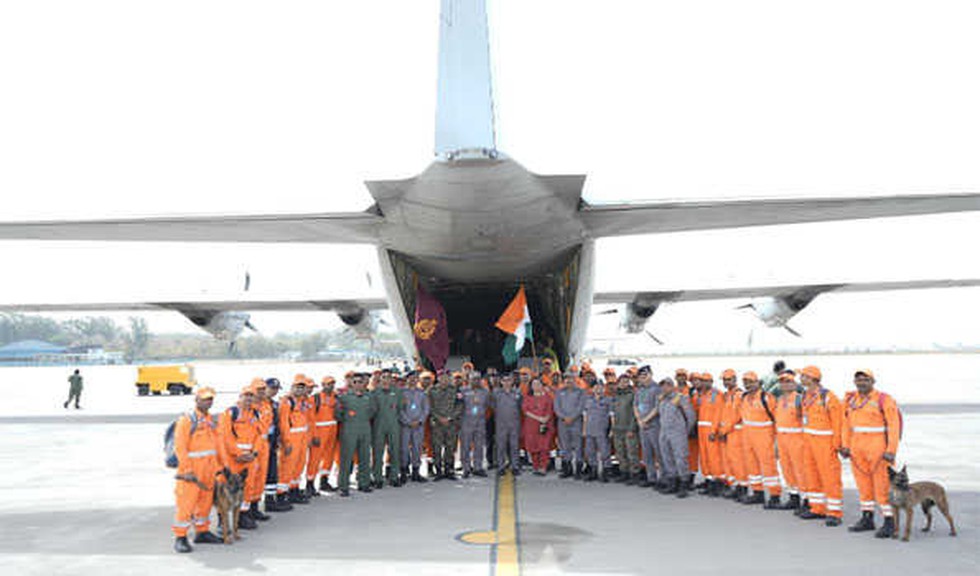
About Operation Brahma:
- It is India's humanitarian mission launched in response to the devastating 7.7-magnitude earthquake that struck Myanmar on March 28, 2025.
- The massive earthquake that devastated Myanmar and neighbouring Thailand killed over 1,600 people and caused widespread destruction.
- The large-scale humanitarian mission includes rescue teams, medical aid, and relief supplies.
- The National Disaster Response Force (NDRF) deployed an 80-member team equipped with concrete cutters, drill machines, plasma cutters, and other rescue tools.
- The Indian Army has mobilised a specialised medical task force to provide urgent humanitarian assistance.
- The Indian Army dispatched a specialized 118-member medical team from the elite Shatrujeet Brigade Medical Responders.
- As part of the mission, the Indian Army will set up a 60-bed Medical Treatment Centre to provide immediate care to those injured in the disaster.
- The facility will be equipped to handle trauma cases, emergency surgeries, and essential medical services to support Myanmar’s strained healthcare system.
- Two Indian naval ships, INS Satpura and INS Savitri, were dispatched carrying 40 tonnes of humanitarian aid to the port of Yangon.
Prelims Pointers
March 30, 2025

About Kasampatty Sacred Grove:
- The Kasampatti Sacred Grove, also known as Veera Kovil Sacred Grove, is a revered ecological and cultural site located in Kasampatti village, Dindigul District, Tamil Nadu.
- Spanning 4.97 hectares near the Alagarmalai Reserve Forest, this grove is enveloped by lush mango plantations, enhancing its natural beauty and fertility.
- It hosts an impressive variety of species - 48 plant species, 22 shrubs, 21 lianas (woody vines), and 29 herbs.
- It also shelters more than 12 species of birds, along with small mammals, reptiles, and numerous insects, highlighting the grove’s genetic richness.
- The Tamil Nadu government has notified Kasampatti Sacred Grove as the state's second Biodiversity Heritage Site under the Biological Diversity Act, 2002.
What are Biodiversity Heritage Sites (BHS)?
- BHS are unique ecosystems having rich biodiversity comprising any one or more of the following components:
- Richness of wild as well as domesticated species or intra-specific categories.
- High endemism.
- Presence of rare and threatened species, keystone species, and species of evolutionary significance.
- Wild ancestors of domestic/cultivated species or their varieties.
- Past preeminence of biological components represented by fossil beds and having significant cultural, ethical, or aesthetic values and are important for the maintenance of cultural diversity, with or without a long history of human association with them.
- Under Section 37 of the Biological Diversity Act, 2002, the State Government, in consultation with local bodies, may notify areas of biodiversity importance as BHS.
- The State Government, in consultation with the Central Government, may frame rules for the management and conservation of BHS.
- The creation of BHS may not put any restriction on the prevailing practices and usages of the local communities other than those voluntarily decided by them.
- The purpose of declaring BHS is to enhance the quality of life of the local communities through the conservation of such sites.
- In 2007, the Nallur Tamarind Grove in Bengaluru, Karnataka, was designated as India's first BHS.
Prelims Pointers
March 30, 2025

What is the Future Circular Collider (FCC)?
- Project scope: A 91 km circular tunnel beneath the Swiss-French border, designed to accelerate and collide particles at unprecedented energies.
- Purpose: To generate Higgs bosons in large numbers (Phase 1, ~2040) and later to collide protons at extreme energies (Phase 2, ~2070).
- Estimated cost: $30 billion (initial), with long-term funding implications for the next decades.
- Supporters: CERN leadership, senior physicists like Fabiola Gianotti and Mark Thomson, claim it will be the most powerful instrument to study nature.
- Critics: Many physicists fear the project will drain funds, limiting investment in other scientific advancements.
Alternative Proposals to FCC
- Linear accelerators: Straight-line accelerators could offer a cheaper and more adaptable approach to studying particle physics.
- Plasma wave technology: Uses plasma waves to accelerate particles in a compact setup, potentially revolutionizing collider design in the next 20 years.
What is a Hadron?
- A hadron is a subatomic particle made of quarks and bound by the strong nuclear force.
- Types of Hadrons:
- Mesons (e.g., pions, kaons)
- Baryons (e.g., protons, neutrons)
What is the Large Hadron Collider (LHC)?
- Location: Franco-Swiss border, operated by CERN.
- Size: 27 km circular tunnel.
- Purpose: Collides protons at high energies to study fundamental forces and particles.
- Discoveries: Higgs boson (2012), confirming the Higgs field, which gives particles mass.
- Speed: Accelerates particles to 999999% the speed of light.
- Significance: Helps replicate Big Bang conditions and test theories like supersymmetry and extra dimensions.
Prelims Pointers
March 30, 2025
- Five species on Socotra Island (Yemen) have moved from Vulnerable to Endangered, one species is now Critically Endangered and three others have been assessed as Critically Endangered for the first time.
What is Frankincense?
- Frankincense is an aromatic resin derived from trees of the Boswellia genus.
- It has been historically valued for use in incense, perfumes, and traditional medicine.
- Cultural significance: It was one of the three gifts (Gold, Frankincense, and Myrrh) presented to Jesus by the Magi, as mentioned in the Bible.
Major Species of Boswellia
|
Scientific Name |
Common Name |
Region Found |
|
Boswellia serrata |
Indian Frankincense |
India |
|
Boswellia carterii |
Somali Frankincense |
Somalia, Ethiopia |
|
Boswellia sacra |
Arabian Frankincense |
Oman, Yemen |
|
Boswellia papyrifera |
Sudanese Frankincense |
Sudan, Eritrea |
|
Boswellia frereana |
Maydi Frankincense |
Somalia |
Why is Frankincense at Risk?
- Habitat destruction & overgrazing: Goats graze on young saplings, preventing tree regeneration.
- Traditional rotational grazing practices have declined, leading to
- Climate change & extreme weather: Frequent cyclones, flash floods, and landslides (2015, 2018) have damaged and uprooted trees.
- Prolonged droughts hinder sapling growth.
- Unsustainable Harvesting: Excessive tapping for resin extraction weakens trees and reduces seed production.
- Limited conservation measures: Lack of effective protective measures like fencing and regulated harvesting has worsened the crisis.
Prelims Pointers
March 30, 2025

About the Amur Tigers
- Scientific name: Panthera tigris altaica
- Common name: Amur Tiger / Siberian Tiger
- IUCN red list status: Endangered
- Population: Estimated 265–486 (2022) in Russia, with a small number in China & possibly North Korea
- Habitat: Primarily in eastern Russia's birch forests, with some presence in China and North Korea
- Diet: Carnivore – Preys on elk, wild boar, and other ungulates
- Size: 10.75 feet in length, weighing up to 660 pounds
- Lifespan: 10-15 years in the wild, up to 20 years in captivity
- Unique adaptations: Thick fur, large size and a lighter coat color for cold climates
Prelims Pointers
March 30, 2025
What is Xenotransplantation?
- Xenotransplantation refers to the transplantation, implantation, or infusion of live cells, tissues, or organs from animals into a human recipient.
- It can also involve human cells, tissues, or organs that have had prior ex vivo (outside the body) contact with non-human animal cells or tissues.
- First attempts at xenotransplantation involving the human heart were made in the 1980s.
- Genetic modifications are required in animal organs to prevent immune rejection by the human body.
- Post-transplantation monitoring is crucial to ensure organ functionality and detect immune responses.
Why Are Pigs Used for Xenotransplantation?
- Pig heart valves have been successfully used for human valve replacements for over 50 years.
- Anatomical and physiological similarities between pigs and humans make pigs ideal organ donors.
- Pigs are widely farmed, making organ availability cost-effective and scalable.
- The variety of pig breeds allows organ size to be matched with specific human requirements.
Recent Advancements in Xenotransplantation
- First Genetically Modified Pig Heart Transplant (2022): A genetically modified pig heart was successfully transplanted into a human for the first time.
- The experiment demonstrated the potential of genetically modified pig organs for human transplantation.
- Gene-Modified Pig Liver Transplantation (2025): Chinese researchers from the Fourth Military Medical University, Xi’an successfully transplanted a gene-edited pig liver into a brain-dead human recipient.
- Key Genetic Modifications:
- Six genes are edited to prevent immune rejection.
- Human transgenes are inserted to enhance compatibility.
- Observations Over 10 Days:
- The pig liver produced bile and albumin, indicating basic functionality.
- Stable blood flow was maintained.
- No signs of rejection were observed due to immunosuppressants.
- The study was published in Nature.
- Potential Use: Gene-modified pig livers could serve as a "bridge therapy" for patients awaiting human organ transplants.
- However, long-term viability and full liver functionality remain uncertain.
Prelims Pointers
March 30, 2025

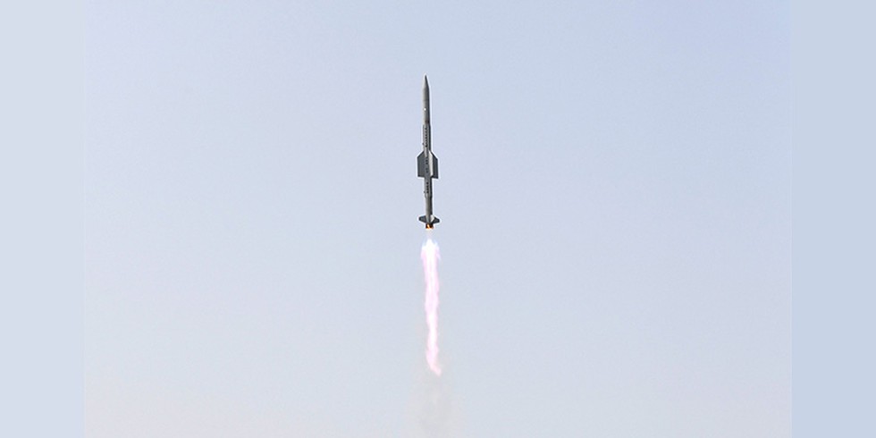
Why in the News?
- ISRO has achieved a breakthrough in developing a semi-cryogenic engine (liquid oxygen/kerosene engine) with a high thrust of 2,000 kN (kilonewtons).
- The first successful hot test of the Engine Power Head Test Article (PHTA) was conducted at the ISRO Propulsion Complex, Mahendragiri, Tamil Nadu.
- This engine will be used in the semi-cryogenic booster stage of the Launch Vehicle Mark-3 (LVM3), enhancing India's space launch capabilities.
About Geosynchronous Transfer Orbit (GTO)
What is a Transfer Orbit?
- A Transfer Orbit is used to move a satellite from one circular orbit to another in a fuel-efficient manner.
- The Hohmann Transfer Orbit is a commonly used maneuver for such transfers.
Geostationary Transfer Orbit (GTO)
- GTO is a highly elliptical orbit with:
- Perigee (closest point to Earth): 180-200 km above Earth’s surface.
- Apogee (farthest point from Earth): ~35,900 km (near geostationary orbit).
- Why is GTO Used?
- Satellites are first placed in GTO before they use their own propulsion system to move to a final geostationary orbit (GEO).
- This reduces the energy required from the launch vehicle, making it more fuel-efficient.
What is a Semi-Cryogenic Engine?
A semi-cryogenic engine is a type of liquid rocket engine that uses:
- Liquid Oxygen (LOX) as an oxidiser (cryogenic component).
- Refined kerosene (RP-1) as fuel (stored at ambient temperature).
Advantages over Cryogenic Engines:
|
Feature |
Cryogenic Engine (LOX + LH2) |
Semi-Cryogenic Engine (LOX + Kerosene) |
|
Fuel used |
Liquid Hydrogen (LH2) |
Refined Kerosene (RP-1) |
|
Density impulse |
Lower |
Higher (more efficient thrust) |
|
Cost |
Expensive |
More Cost-Effective |
|
Storage |
Requires Ultra-Cold Storage (-253°C) |
Kerosene stored at normal temperature |
|
Handling |
Difficult |
Easier |
Significance of ISRO’s Semi-Cryogenic Engine Development
- Engine power head test success: The hot test of the Power Head Test Article (PHTA) was conducted for 2.5 seconds to validate the ignition and boost strap mode operation.
- All engine parameters performed as expected.
- Developed by: Liquid Propulsion Systems Centre (LPSC) under ISRO.
- Upcoming plans: Further series of tests on PHTA before realizing the fully integrated engine.
- Replacement for Current LVM3 Core Stage:
- The SC120 stage (powered by SE2000 engine) will replace the existing L110 stage in LVM3.
- Payload capacity in Geosynchronous Transfer Orbit (GTO) to increase from 4 tonnes to 5 tonnes.
Key Differences: Cryogenic vs Semi-Cryogenic Engines
|
Feature |
Cryogenic Engine (LOX + LH2) |
Semi-Cryogenic Engine (LOX + Kerosene) |
|
Oxidizer used |
Liquid Oxygen (LOX) |
Liquid Oxygen (LOX) |
|
Fuel used |
Liquid Hydrogen (LH2) |
Refined Kerosene (RP-1) |
|
Storage |
Requires ultra-cold storage (-253°C) |
Can be stored at normal temperature |
|
Efficiency |
Lower density impulse |
Higher density impulse (more efficient thrust) |
|
Cost |
Expensive |
More cost-effective |
|
Handling |
Difficult to store and handle |
Easier to store and handle |
|
Used in |
Cryogenic Upper Stages of rockets |
Booster stages of heavy-lift launch vehicles |
March 29, 2025
Prelims Pointers
March 29, 2025
Why in the News?
- The Government of India has announced the establishment of the Second National Gene Bank to conserve 10 lakh crop germplasm for ensuring future food and nutritional security.
- This initiative is part of the “Investing in Innovations” theme of the Union Budget 2025-26.
What is a Gene Bank?
- A Gene Bank is a storage facility that preserves seeds, pollen, and plant tissues to protect plant species from extinction and ensure their availability for future use.
- These stored samples help in crop breeding, scientific research, and biodiversity conservation.
- Gene banks play a crucial role in maintaining genetic diversity, essential for climate resilience and food security.
India’s First National Gene Bank
- It was established in 1996 by the Indian Council of Agricultural Research - National Bureau of Plant Genetic Resources (ICAR-NBPGR) in New Delhi.
- Current Status:
- Second-largest Gene Bank globally after the Svalbard Global Seed Vault in Norway.
- Houses 4,71,561 accessions of 2,157 species.
- Provides plant genetic resources for use by both the public and private sectors involved in crop improvement and genetic conservation.
National Bureau of Plant Genetic Resources (NBPGR)
- Apex Institution under the Indian Council of Agricultural Research (ICAR).
- Objective: Conservation, evaluation, and utilization of plant genetic resources for sustainable agriculture and food security.
- Headquarters: New Delhi.
National Gene Fund
- Established under Section 45 of the Protection of Plant Varieties and Farmers’ Rights Act, 2001 (PPVFR Act).
- Objective:
- Ensures fair distribution of benefits derived from genetic resources.
- Supports conservation efforts and promotes sustainable farming practices.
Provides financial incentives to farmers and institutions engaged in biodiversity conservation
Prelims Pointers
March 29, 2025

About Greenland
- Geographical location: North Atlantic Ocean, between North America and Europe
- Capital: Nuuk
- Highest point: Gunnbjørn’s Fjeld
- Climate: Arctic climate, with temperatures ranging from -50°C in winter to 10–15°C in summer
- Natural resources: Minerals, oil, gas, and rare earth elements
- Strategic importance: Pituffik Space Base is crucial for US missile defense systems
- Historical and Political background: Greenland is an autonomous territory of Denmark but holds strategic significance due to its location between North America and Europe.
- The island was a Danish colony until 1979, when it gained home rule; in 2009, it achieved self-governing status, but foreign policy, defense, and monetary matters remain under Denmark’s control.
US Interests in Greenland
- Strategic military location: The Pituffik Space Base is crucial for the US ballistic missile warning system due to its position along the shortest route between North America and Europe.
- The 1951 Agreement allows the US access to the base but requires prior notification to Greenland and Denmark.
- Natural resources and economic interests: Greenland is rich in minerals, oil, and natural gas, including rare earth minerals, which are vital for US economic and technological interests.
- Despite this, most mining companies operating in Greenland are Australian, Canadian, or British.
- US attempts to acquire Greenland: In 2019, Trump proposed to buy Greenland from Denmark, but the offer was rejected.
- In 2025, Trump reaffirmed his belief that the US should control Greenland, arguing it is strategically and economically necessary.
Prelims Pointers
March 29, 2025

What is BIMSTEC?
- BIMSTEC (Bay of Bengal Initiative for Multi-Sectoral Technical and Economic Cooperation) is a regional multilateral organization that connects South Asia and Southeast Asia.
- Established through the Bangkok Declaration in 1997, it promotes economic and social progress in the region.
- Member Countries
- South Asia: Bangladesh, Bhutan, India, Nepal, Sri Lanka.
- Southeast Asia: Myanmar, Thailand.
Evolution of BIMSTEC
- Initially formed as ‘BIST-EC’ (Bangladesh, India, Sri Lanka, and Thailand Economic Cooperation).
- Renamed ‘BIMST-EC’ after Myanmar joined in 1997.
- In 2004, Nepal and Bhutan joined, leading to the current name,
Key Features
- Bridges South and Southeast Asia, linking the Himalayan region with the Bay of Bengal.
- Focuses on economic growth, trade, technology, energy, security, and connectivity.
- Acts as an alternative to SAARC for regional cooperation.
India’s role in BIMSTEC
- Leading initiatives in trade, security, maritime cooperation, and climate action.
- Key proponent of BIMSTEC Free Trade Agreement to enhance regional trade integration.
- Advocates for stronger physical and digital connectivity between BIMSTEC nations.
India’s Strategic Vision in BIMSTEC
- Neighbourhood First Policy: Prioritising economic and security ties with South Asian neighbors.
- Act East Policy: Strengthening engagements with ASEAN and Southeast Asia.
- MAHASAGAR Vision: Enhancing India’s role in global maritime security and economic growth.
- This visit marks India’s continued commitment to its ‘Neighbourhood First’ and ‘Act East’ policies, as well as its MAHASAGAR Vision (Mutual and Holistic Advancement for Security and Growth Across Regions).
Prelims Pointers
March 29, 2025
About the Teesta River:
- Geographical significance: The Teesta River is a major transboundary river flowing through India and Bangladesh, serving as a crucial water resource for both nations.
- Origin: The river originates from the Tso Lhamo Lake at an elevation of approximately 5,280 meters in North Sikkim, India.
- Other sources cited include the Pahunri Glacier, Khangse Glacier, and Chho Lhamo Lake.
- Course: The Teesta flows southward through the Sikkim Himalayas, passing towns like Rangpo, and then through West Bengal before entering Bangladesh, where it joins the Brahmaputra River (known as the Jamuna River in Bangladesh).
- Length and basin area: The river spans approximately 414 kilometers, with a drainage basin covering around 12,540 square kilometers. Notably, 83% of the basin lies in India, while 17% is in Bangladesh.
- Tributaries:
- Left-bank tributaries: Lachung Chhu, Chakung Chhu, Dik Chhu, Rani Khola, and Rangpo Chhu.
- Right-bank tributaries: Zemu Chhu, Rangyong Chhu, and Rangit River.
- Hydroelectric projects and barrages:
- In India:
- Teesta-V Dam: 510 MW, located in Gangtok district, Sikkim.
- Teesta-III Dam: 1,200 MW, situated in Mangan district, Sikkim.
- Teesta Low Dam III & IV: 132 MW and 160 MW respectively, both in Kalimpong district, West Bengal.
- Gajoldoba Barrage: Primarily for irrigation purposes in West Bengal.
- In Bangladesh:
- Duani Barrage: Used mainly for irrigation.
- Barakhata Teesta Barrage: Another significant irrigation infrastructure.
- In India:
Prelims Pointers
March 29, 2025

About Earthquakes
- Earthquake: Sudden shaking or trembling of the Earth's surface due to the release of stored energy in the Earth's crust or upper mantle.
- Focus (Hypocentre): The point within the Earth where the earthquake originates.
- Epicentre: The point on the surface directly above the focus.
- Seismograph: An instrument used to detect and measure
- Isoseismic line: A line connecting points on the surface experiencing the same intensity.
Types of Seismic Waves
|
Type |
Description |
Speed |
|
Primary (P) Waves |
Fastest, travel through solids, liquids, and gases |
Fastest |
|
Secondary (S) Waves |
Travel through solids only, cause more damage |
Slower than P-waves |
|
Surface Waves |
Slowest, cause maximum destruction |
Slowest |
Causes of Earthquakes
- Fault zones: Most earthquakes occur along fault lines, where stress builds up due to tectonic movements.
- Major faults:
- Thrust faults (Convergent boundary) → Most powerful quakes (Magnitude 8+).
- Strike-slip faults (Transform boundary) → Horizontal movement (e.g., Sagaing Fault, San Andreas Fault).
- Normal faults (Divergent boundary) → Less intense quakes (Magnitude <7).
- Plate Tectonics: Tectonic movement at plate boundaries can trigger earthquakes:
- Convergent Boundaries → Subduction zones, causing megathrust earthquakes (e.g., 2004 Indian Ocean earthquake).
- Divergent Boundaries → Spreading ridges generate mild earthquakes.
- Transform Boundaries → Horizontal movement of plates leads to strike-slip earthquakes (e.g., Sagaing Fault, San Andreas Fault).
- Volcanic activity: Magma movement inside volcanoes can cause volcanic earthquakes.
- Myanmar has active volcanoes, contributing to seismic activity.
- Human-induced earthquakes: Mining, dam construction, and deep drilling can trigger artificial seismic activity.
Why Does Myanmar Experience Frequent Earthquakes?
- Tectonic Setting: Myanmar lies at the junction of three major tectonic plates:
- Indian Plate (moving northward)
- Eurasian Plate (moving southward)
- Burma Microplate (moving eastward)
- The Sagaing Fault, a strike-slip fault, runs north-south through central Myanmar, making it highly prone to seismic activity.
Prelims Pointers
March 29, 2025
About Tadoba-Andhari Tiger Reserve:
- Location: It is located in the Chandrapur district in Maharashtra.
- It is the largest and oldest Tiger Reserve of Maharashtra.
- The origin of the name "Tadoba" lies with the name of the god "Tadoba" or "Taru",worshipped by the tribes that live in the dense forests of the Tadoba and Andhari regions. "Andhari" refers to the Andhari River that meanders through the forest.
- The total area of the reserve is 625.4 sq. km. This includes Tadoba National Park, covering 116.55 sq. km, and Andhari Wildlife Sanctuary, covering 508.85 sq. km.
- Corridor: The reserve has corridor linkages with Nagzira-Navegaon and Pench Tiger Reserves within the State.
- Habitat:
- Biogeographically, the reserve falls in the Central Plateau province of the Deccan Peninsula.
- The habitat has undulating topography in the north and is rich in biodiversity.
- Vegetation: Southern Tropical Dry Deciduous
- There are two lakes and one waterway in the reserve, Tadoba Lake, Kolsa Lake, and the Tadoba River.
- Flora:
- It is blessed with thick forests covered with teak trees and other vegetation such as crocodile bark, salai, tendu, karaya gum, and mahua madhuca.
- The reserve is adorned with patches of grass and bamboo shrubberies.
- Fauna:
- The notable faunal species include the tiger, leopard, sloth bear, wild dog, gaur, chital, and sambar.
- As many as 280 species of birds are found, apart from reptiles (54 species), amphibians (11 species), and fishes (84 species).
Prelims Pointers
March 29, 2025
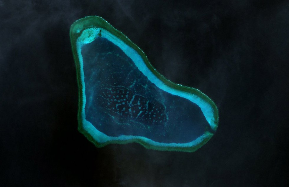
About Scarborough Shoal:
- The Scarborough Shoal (also known in English as the Scarborough Reef) is an oceanic coral atoll that developed on top of a seamount into a triangle shape in the eastern part of the South China Sea.
- It is located some 220 kilometers west of the Philippines’ Island of Luzon.
- It is the largest atoll in the South China Sea, submerged at high tide with few rocks above sea level.
- This atoll extends 18 km along its northwest-southeast axis and reaches 10 km along its northeast-southwest axis.
- The deep waters around the shoal make it a productive fishing area, rich in marine life, and the lagoon also contains many commercially valuable shellfish and sea cucumbers.
- The shoal is the source of an ongoing and, so far, unresolved dispute between the People’s Republic of China and the Philippines, with both countries claiming that the shoal lies within their territory and saying they have exclusive rights to access its waters.
- There are no structures built on Scarborough Shoal, but the feature is effectively controlled by China, which has maintained a constant coast guard presence at the feature since 2012.
- China, which now refers to the shoal as Huangyan Island, makes a historical claim to the area, stating that they can trace their ownership of the area back to the Yuan Dynasty of the 1200s.
- The Philippines claim the area on the basis of geography, as it is much closer to the Philippines’ main island of Luzon, which contains the capital, Manila, but lies over 500 miles from China.
- It is considered within the Philippines’ 200-nautical mile exclusive economic zone, based on the 1982 United Nations Convention on the Law of the Sea (UNCLOS).
Prelims Pointers
March 29, 2025
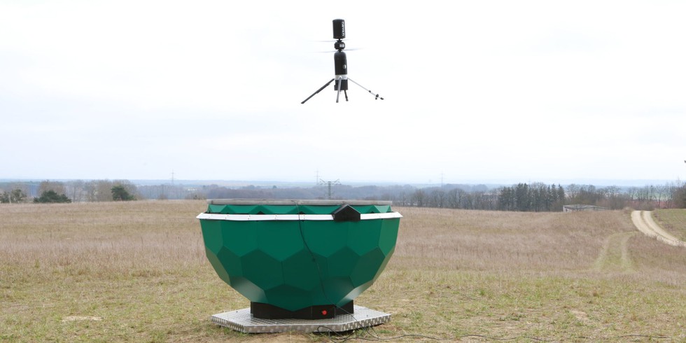
About Silvaguard Drone:
- It is an AI-based drone designed to enhance the early detection, location, and monitoring of wildfires.
- It was introduced by Dryad Networks, an environmental IoT startup based in Berlin.
- The drone will deliver infrared images, among other things, and works in combination with a fire detection system that the company developed earlier and that's already being used in several countries.
- The fire detection system, called Silvanet, is designed to detect wildfires at the smoldering stage using solar-powered gas sensors connected via a wireless network.
- Each gas sensor can protect an area the size of a football field and be attached to a tree.
- The plan is that once Silvanet detects a fire, it will trigger a nearby Silvaguard drone to fly to the location and provide detailed images.
- The information about the fire, including geographic coordinates, video and infrared images, will then be sent to the firefighters who will then know where the fire is spreading and how big it is.
- The system aims to enhance firefighting efficiency by delivering precise fire locations and statuses in real-time.
Prelims Pointers
March 29, 2025
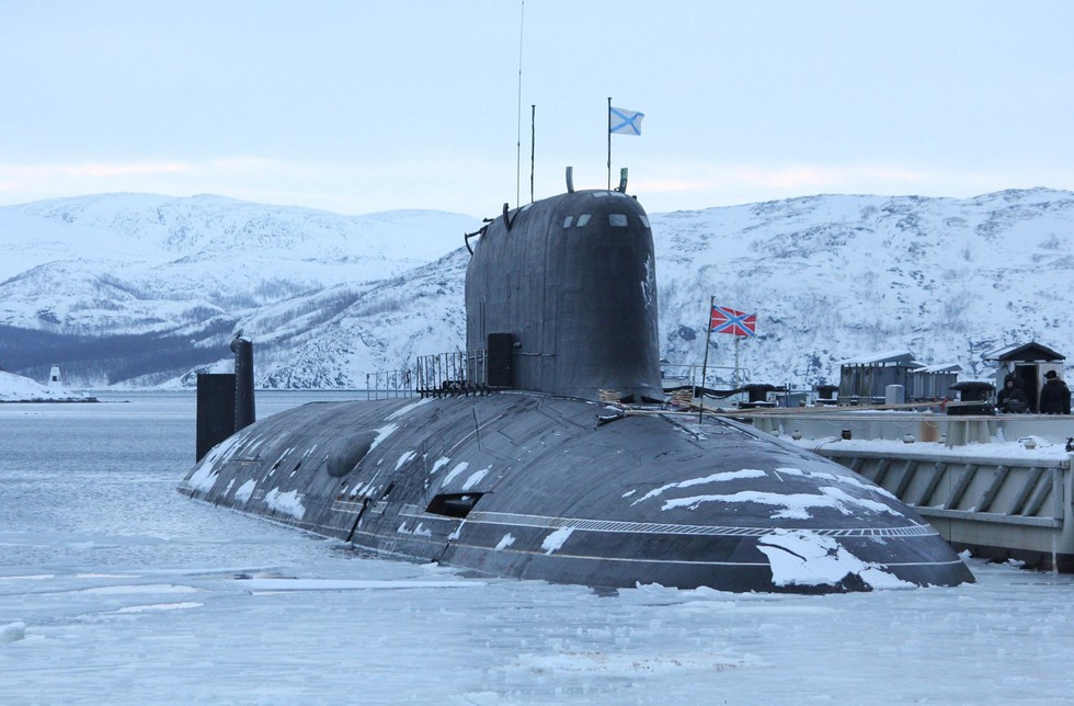
About Perm Submarine:
- It is a fourth-generation nuclear-powered attack submarine belonging to the Yasen-M class (Project 885M).
- Named after the city of Perm in the Urals, it is the sixth vessel in the Yasen/Yasen-M series and the first Russian nuclear submarine to be officially equipped with the 3M22 Zircon hypersonic cruise missile as a standard feature.
- It is scheduled to enter service with the Russian Navy in 2026.
- Features:
- It is powered by a pressurized water-cooled nuclear reactor generating 200 megawatts (approximately 268,204 hp).
- It can reach speeds of up to 31 knots underwater and 16 knots on the surface.
- It has a 25–30-year core life, eliminating the need for mid-life refueling, and allows natural coolant circulation, contributing to lower acoustic signatures.
- With a maximum diving depth of 600 meters and an operational depth of 520 meters, the Perm can remain submerged for up to 100 days.
- Its overall length is 130 meters, with a beam of 13 meters and a draft of 9.4 meters, and it accommodates a crew of 64 members.
Prelims Pointers
March 29, 2025
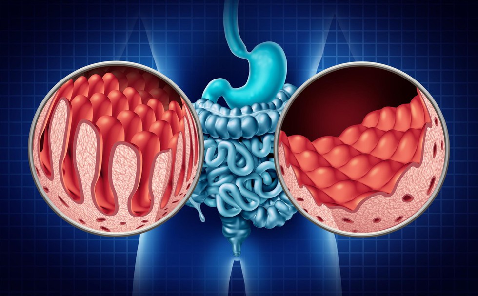
About Coeliac Disease:
- It is an inherited autoimmune disorder.
- Cause:
- It is caused by an immune reaction to eating gluten.
- Gluten is a protein found in foods containing wheat, barley, or rye.
- If you have coeliac disease, eating gluten triggers an immune response to the gluten protein in your small intestine.
- Over time, this reaction damages your small intestine's lining and prevents it from absorbing nutrients, a condition called malabsorption.
- It is caused by an immune reaction to eating gluten.
- Symptoms:
- The intestinal damage often causes symptoms such as diarrhea, fatigue, weight loss, bloating, or anemia.
- It also can lead to serious complications if it is not managed or treated.
- In children, malabsorption can affect growth and development in addition to gastrointestinal symptoms.
- People having a first-degree relative with coeliac disease (parent, child, sibling) have a 1 in 10 risk of developing coeliac disease.
- Coeliac disease can develop at any age after people start consuming gluten.
- It is estimated to affect 1 in 100 people
- Treatment:
- There's no definite cure for coeliac disease.
- But for most people, following a strict gluten-free diet can help manage symptoms and help the intestines heal.
March 28, 2025
Prelims Pointers
March 28, 2025

About Debrigarh Wildlife Sanctuary:
- Location: It is situated in the Bargarh district of Odisha near the Hirakud dam (Mahanadi River).
- It finds a special mention because of noted freedom fighter Veer Surendra Sai.
- During his rebellion against the British, his base at ‘Barapathara” was located within the sanctuary.
- It was declared a wildlife sanctuary in 1985.
- Vegetation: Dry deciduous mixed forests.
- Flora: Major trees found here are Sal, Asana, Bija, Aanla, Dhaura etc.
- Fauna: A huge variety of wild animals reside in the dense forest of the sanctuary, such as Tiger, Sloth Bear, Leopard, Hyena, Spotted Deer, Antelopes, Sambar, Gaur, Nilgai, Bison, Langur Monkeys etc.
Key facts about Indian Bison:
- Indian Bisons are one of the largest extant bovines. It is one of the largest species among the wild cattle, reaching a shoulder height of up to 220 cm.
- Habitat: They are found on the forested hills and grassy areas of south to southeast Asia.
- Distribution:
- There are about 13,000 to 30,000 gaurs in the world with approximately 85% of the population present in India. It is also found in Burma and Thailand.
- The Western Ghats in southern India constitute one of the most extensive extant strongholds of gaur, in particular in the Wayanad – Nagarhole – Mudumalai – Bandipur complex.
- The gaur is the State Animal of Goa and Bihar.
- Conservation:
- IUCN: Vulnerable
- CITES: Appendix I
- The Wild Life Protection Act, 1972: Schedule I
Prelims Pointers
March 28, 2025
About Exercise Prachand Prahar:
- It is a tri-service integrated multi-domain warfare exercise conducted in the high-altitude terrain of Arunachal Pradesh.
- It was conducted ‘deep’ in the high-altitude terrain of Arunachal Pradesh in the eastern sector of the 3,488-km long Line of Actual Control (LAC).
- It was carried out under the aegis of the Eastern Army Command.
- The exercise involved the Army, IAF and the other combat elements in a synergised combat drill designed to simulate future warfare.
- It commenced with the deployment of advanced surveillance resources of all three services, including long-range surveillance aircraft of the IAF and the maritime domain awareness aircraft of the Indian Navy, helicopters, and Unmanned Aerial Vehicles (UAVs), along with space resources and the Indian Army’s elite special forces to create seamless domain awareness and detect simulated targets.
- Once identified, these targets were swiftly destroyed through the synchronised joint firepower of fighter aircrafts, long-range rocket systems, medium artillery, armed helicopters, swarm drones, loitering munitions, and kamikaze drones in an electronically contested environment.
- The ‘Exercise Prachand Prahar’ validated integrated planning, command and control, as well as seamless execution of surveillance and firepower platforms across the three services, covering the entire spectrum of conflict.
- This exercise is in continuation with ‘Exercise Poorvi Prahar’ held in November 2024, which had focused on the integrated application of aviation assets.
Prelims Pointers
March 28, 2025
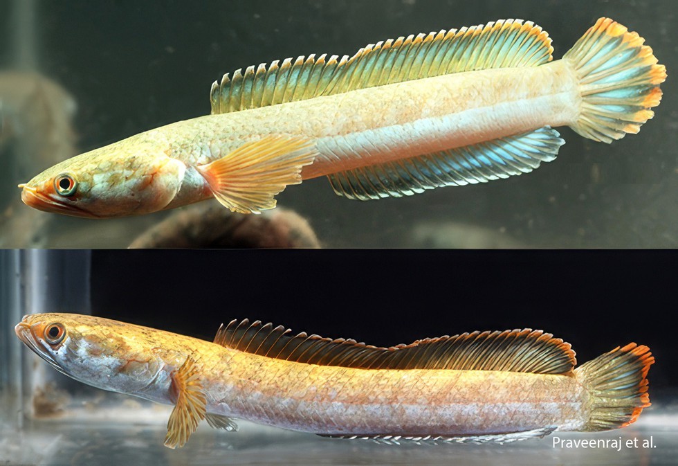
About Channa nachi:
- It is a new species of snakehead fish.
- It was found in a shallow, slow-flowing stream that feeds into the Simsang River system near Chokpot village, Meghalaya, a waterbody with a substrate of sand, leaf litter, and pebbles—an ideal habitat for lesser-known aquatic species.
- The stream is also home to other freshwater fish species such as Schistura reticulofasciata, Dario kajal, Pseudolaguvia sp., and Barilius bendelisis, but Channa nachi stands out for its striking appearance and distinct characteristics.
- Features:
- Medium-sized snakehead species with an attractive bicolor body.
- A slender body with a unique creamish-yellow to greyish-blue coloration.
- Pale-blue marbling on the ventral area.
- 10–12 pale brown saddles on the dorsal half.
- No spots or blotches.
- No transverse markings on the caudal fin.
Prelims Pointers
March 28, 2025
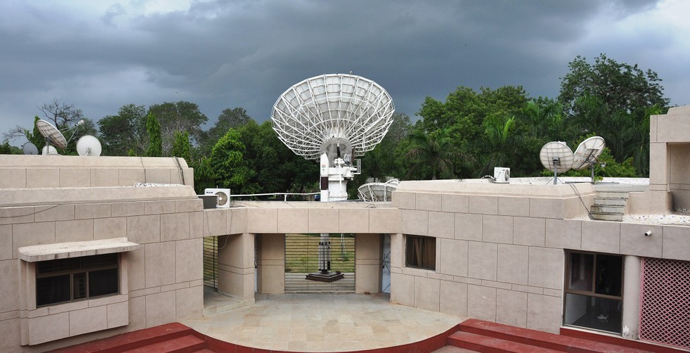
About Bhaskaracharya National Institute for Space Applications and Geo-informatics (BISAG-N):
- It is an autonomous scientific society registered under the Societies Registration Act, 1860, under the Ministry of Electronics & Information Technology (MeitY), Government of India.
- Location: Gandhinagar, Gujarat
- Objective: To undertake technology development & management, research & development, facilitate national and international cooperation, capacity building, and support technology transfer & entrepreneurship development in the area of geospatial technology.
- BISAG-N has three main domain areas: satellite communication, geo-informatics and geo-spatial technology.
- BISAG-N provides specialized services and solutions in implementing map-based Geographic Information Systems (GIS).
- BISAG-N undertakes all services for the entire process of implementing an enterprise level GIS system.
- These services include GIS database design and development, map creation/updation and finishing, data migration/conversion and format translation, software development and customization, systems integration, and technical consulting.
- BISAG-N also provides complete GIS solutions, which bundle hardware and software with GIS systems development services.
- BISAG-N offers comprehensive GIS/Photogrammetric solutions over large geographical areas.
- These include solutions and services in the areas of mapping, cartography, imaging, photogrammetry, and utility/environment resource management. BISAG-N provides solutions based on Remote Sensing, using multispectral data, for specific applications like agricultural crop monitoring, watershed management, forest fire mapping, etc.
- The Institute works in close coordination with Ministries and State Government departments/agencies and has thus emerged as a National level agency to use satellite communication and Space & Geo-spatial technologies for the planning and development activities in various sectors of the Government.
Prelims Pointers
March 28, 2025

About US Commission on International Religious Freedom (USCIRF):
- It is a S. federal government commission created by the International Religious Freedom Act of 1998.
- Functions: USCIRF reviews the facts and circumstances of violations of religious freedom internationally and makes policy recommendations to the President, the Secretary of State, and Congress.
- USCIRF's nine commissioners are appointed by either the President or Congressional leaders of each political party.
- Their work is supported by a professional, nonpartisan staff.
- USCIRF issues an annual report that assesses the US government’s implementation of IRFA, highlights “Countries of Particular Concern” engaging in severe religious freedom violations, documents the conditions of religious freedom in many countries, and provides policy recommendations.
- It uses international standards to monitor religious freedom violations globally.
- Article 18 of the Universal Declaration of Human Rights affirms that:
- “Everyone has the right to freedom of thought, conscience, and religion; this right includes freedom to change his religion or belief, and freedom, either alone or in community with others and in public or private, to manifest his religion or belief in teaching, practice, worship, and observance.”
Prelims Pointers
March 28, 2025

Why in the News?
- NATO clarified its earlier statement regarding the status of four missing U.S. soldiers in Lithuania, emphasising that "the search is ongoing."
- Initial confusion arose when NATO Secretary-General Mark Rutte suggested that the soldiers had died. Still, later, NATO stated that Rutte was referring to unverified news reports rather than confirming their fate.
- The soldiers were part of the S. Army’s 1st Brigade, 3rd Infantry Division, conducting training exercises near Pabradė, Lithuania, close to the Belarus border.
- Their armored vehicle was found submerged in water, and recovery efforts are underway.
Geopolitical Context
- Lithuania, Latvia, and Estonia are NATO members with tense relations with Russia and Belarus.
- Russia’s invasion of Ukraine (2022) has further strained regional security dynamics, increasing military exercises and NATO presence in the Baltic region.
- Belarus, a close ally of Russia, shares borders with Lithuania, Latvia, and Poland, making NATO operations in these areas strategically significant.
About NATO (North Atlantic Treaty Organization)
|
Aspect |
Details |
|
Founded |
1949, with the signing of the North Atlantic Treaty (Washington Treaty) to counter Soviet expansion in post-World War II Europe. |
|
Headquarters |
Brussels, Belgium |
|
Nature |
Military & political alliance of 32 countries from Europe & North America. |
|
Core Principle |
Collective Defense (Article 5): An attack on one NATO country is considered an attack on all. Invoked only once after the 9/11 attacks (2001). |
|
Founding Members (12) |
Belgium, Canada, Denmark, France, Iceland, Italy, Luxembourg, Netherlands, Norway, Portugal, UK, USA. |
|
Latest Expansion |
Sweden joined NATO in 2024. |
|
Ukraine's NATO Bid |
Applied in 2022, received security assurances at Vilnius Summit (2023). |
|
Non-NATO EU Members |
Austria, Cyprus, Ireland, and Malta. |
Prelims Pointers
March 28, 2025
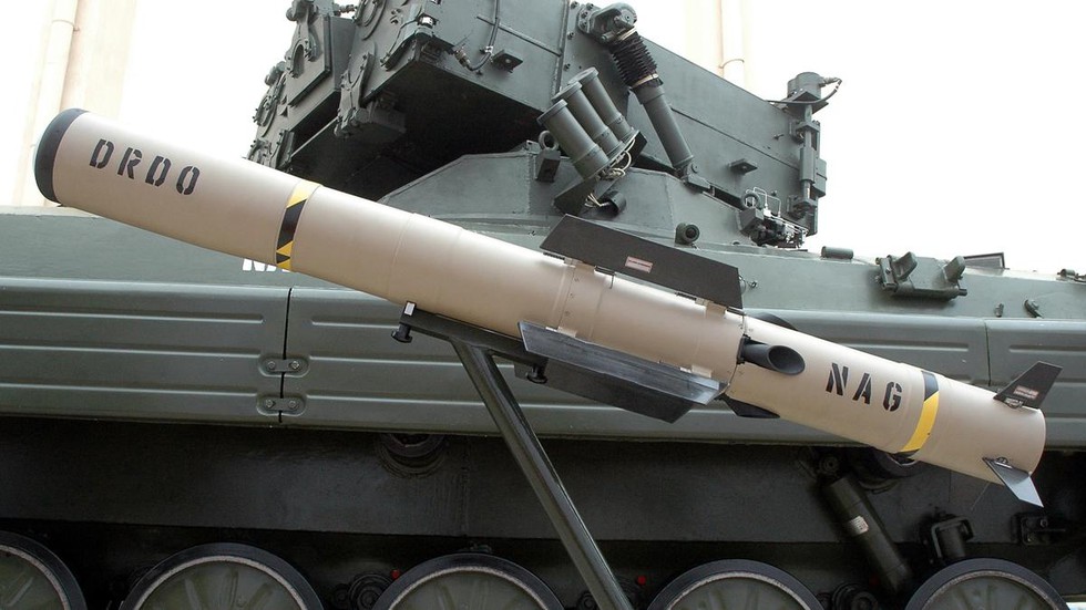
About Nag Anti-Tank Missile System (NAMIS)
Developed By:
- Defence Research and Development Laboratory (DRDL), DRDO
- Production by Bharat Dynamics Limited (BDL)
Key Features:
- NAMIS is a tracked version of the Nag Anti-Tank Guided Missile (ATGM) mounted on a BMP-2 chassis.
- Third-generation ‘fire-and-forget’ missile that locks onto targets using an Imaging Infrared (IIR) Seeker before launch.
- Designed to destroy heavily armored enemy tanks, including those equipped with composite and reactive armor.
- Night-strike capability for operations in low visibility conditions.
- Attack Modes:
- Top Attack Mode: Missile climbs after launch and dives onto the target from above.
- Direct Attack Mode: The Missile travels at a lower altitude and directly hits the target.
- Range: 500 meters to 4 km.
- NAMICA (Nag Missile Carrier):
- Based on Russian-origin BMP-2 Infantry Fighting Vehicle.
- Amphibious capability for mobility across varied terrains.
Other Versions of Nag ATGM:
- Helina (Helicopter-Launched Version):
- Successfully tested in 2018.
- Developed for Rudra and Light Combat Helicopters (LCHs).
Prelims Pointers
March 28, 2025
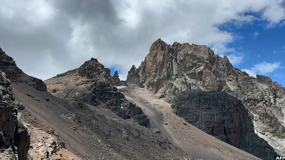
Why in the News?
- The Lewis glacier, once a prominent ice mass, has now shrunk significantly, with studies predicting Mount Kenya could become entirely ice-free by 2030.
- A 2011 study from Austria’s University of Innsbruck reported that Lewis Glacier lost 90% of its volume between 1934 and 2010.
- A 2023 satellite study found that only 4.2% of the ice observed in 1900 remains today.
About Mount Kenya
- Location: Central Kenya, just south of the Equator.
- Elevation: 5,199 meters (17,058 feet) at its highest peak (Batian).
- UNESCO World Heritage Site: Designated in 1997 for its ecological and cultural significance.
- Geological Origin: A long-extinct stratovolcano, heavily eroded over time.
- Glaciers: Home to Lewis Glacier and Tyndall Glacier, among the last remaining tropical glaciers in Africa.
Prelims Pointers
March 28, 2025

About the Gaia Mission
- Originally named Global Astrometric Interferometer for Astrophysics (GAIA), later simplified to Gaia.
- Launched in 2013 by the European Space Agency (ESA), it aimed to create the most precise 3D map of the Milky Way through astrometry (measuring positions and movements of celestial bodies).
- Position: Placed at Lagrange Point 2 (L2), 5 million km from Earth (behind Earth when viewed from the Sun), ensuring an unobstructed cosmic view.
- Scientific Instruments:
- Twin Telescopes: Captured light from different directions.
- Digital Camera: Nearly 1 billion pixels, the largest ever flown in space.
- Three Key Instruments:
- Astrometer: Measures precise locations of celestial bodies.
- Photometer: Determines brightness and temperature of stars.
- Spectrometer: Identifies chemical composition and motion of objects.
Key Discoveries of Gaia
- Mapping the Milky Way in 3D: The First precise 3D map of the Milky Way galaxy also helped understand the shape of the galaxy, including:
- The central bar and spiral arms.
- A warped, wobbly disc, likely caused by past collisions with smaller galaxies.
- Ripples in the galaxy from these collisions may have led to the formation of new stars, including the Sun.
- Discovery of New Black Holes: A new class of black holes that are invisible and can only be detected by their gravitational effects.
- Discovered one of the closest black holes to Earth.
- Tracking asteroids and space threats: Gaia identified over 1,50,000 asteroids, tracking their orbits and potential threats to Earth.
Prelims Pointers
March 28, 2025

Why in the News?
- In February 2024, Union Home Minister Amit Shah announced that the Free Movement Regime (FMR) along the India-Myanmar border would be scrapped.
- The decision was reportedly influenced by former Manipur CM N. Biren Singh, who blamed unregulated cross-border movement for fueling ethnic conflict in Manipur.
- However, Mizoram and Nagaland opposed the decision, and no official notification or bilateral agreement has been made yet.
- The FMR was introduced in 1968 and initially allowed movement up to 40 km, later reduced to 16 km in 2004, with additional regulations enforced in 2016.
About Free Movement Regime (FMR)
- The FMR is a bilateral arrangement between India and Myanmar that permits unrestricted movement within 16 km on either side of the 1,643 km Indo-Myanmar border (IMB).
- Eligibility: Any member of the hill tribes (whether an Indian or Myanmar citizen) can cross the border with a border pass valid for one year and stay for up to two weeks per visit.
- Objective:
- To maintain historical, cultural, and social ties between the trans-border communities.
- To boost local trade and facilitate familial visits.
- To serve as a unique case of cross-border cooperation under India’s Act East Policy.
- Implementation:
- Introduced formally in 2018, although movement existed informally for centuries.
- Inspired by India's Act East Policy, which aims to strengthen ties with Southeast Asian nations.