About the Mission
- The European Space Agency (ESA) is launching a pioneering mission called the Biomass Mission, scheduled for April 29, 2025.
- The satellite will be launched aboard a Vega C rocket from Korou Spaceport in French Guiana.
- It will be placed in a sun-synchronous orbit at an altitude of approximately 666 km, ensuring the satellite observes the Earth under consistent lighting conditions.
Objective and Significance
- The Biomass Mission aims to generate the first-ever global measurements of forest biomass, providing data that is currently severely lacking at a planetary scale.
- The mission seeks to map the world’s forests and understand how they are changing over time, contributing to the study of the global carbon cycle.
- Forests are a vital component of the carbon cycle, acting as carbon sinks. They currently store 861 gigatonnes of carbon in vegetation and soils and absorb around 16 billion metric tonnes of CO₂ annually.
- By tracking changes in forest carbon content, the mission will improve our understanding of carbon emissions, deforestation, and climate change.
- The mission responds to urgent concerns: in 2023 alone, the planet lost 3.7 million hectares of tropical forests—equivalent to losing 10 football fields of forest per minute, contributing to about 6% of global CO₂ emissions.
Key Technologies Used
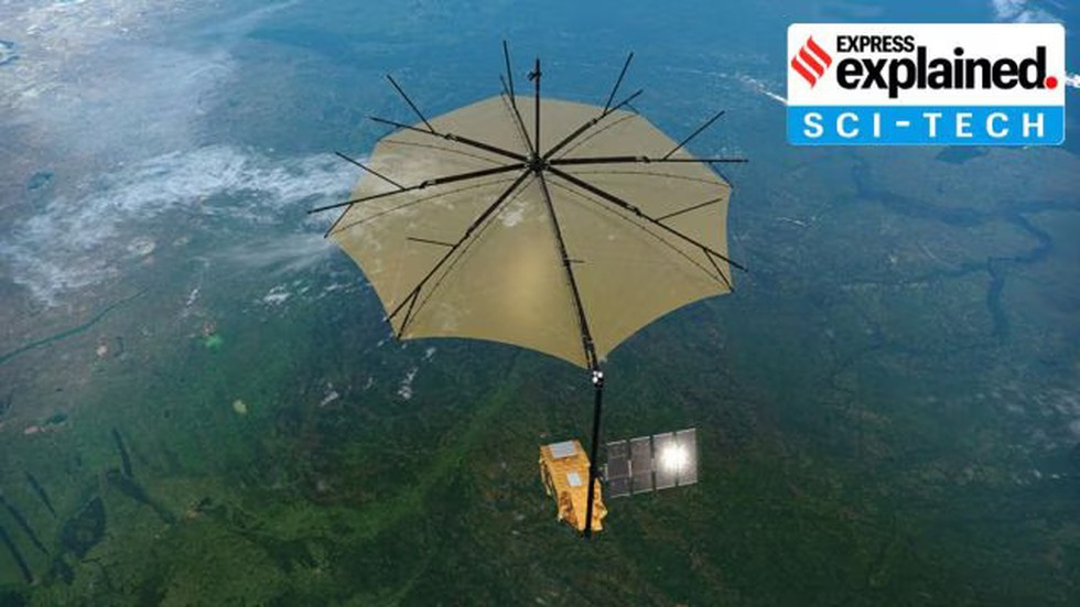
- The satellite is equipped with a 12-meter antenna and utilizes Synthetic Aperture Radar (SAR) to map the Earth's surface.
- Notably, it is the first satellite in space to use a P-band SAR, which is a long-wavelength radar system capable of penetrating dense forest canopies.
- This advanced technology allows measurement of carbon stored both in the canopy and on the forest floor, offering insights into how much biomass and hence, carbon is present.
- Since longer wavelengths penetrate more deeply than shorter ones, the P-band SAR is uniquely suited for generating 3D images of forests, from the canopy down to the tree roots.