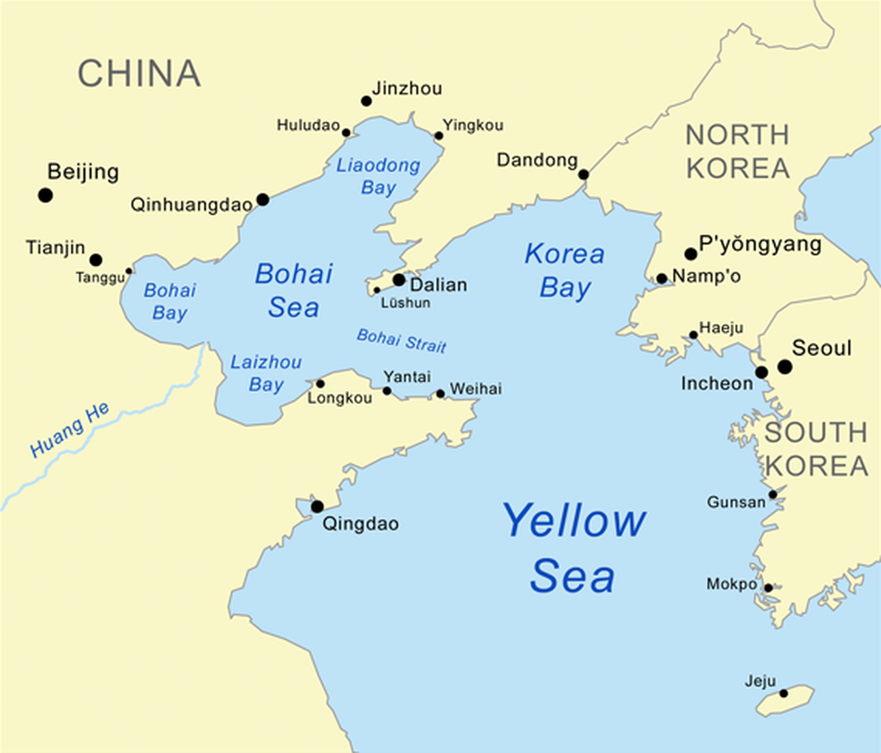
About Bohai Gulf:
- It is the innermost gulf of the Yellow Seaon the coast of Northeastern and North China.
- It is sometimes called Bohai Sea, or Bo Hai for short; in earlier times it was called the Gulf of Chili or the Gulf of Pechili.
- It is approximately 78,000 sq.km in area, and its proximity to Beijing, the capital of China, makes it one of the busiest seaways in the world.
- The Bohai Gulf is enclosed by the Liaodong Peninsula(northeast) and the Shandong Peninsula (south).
- Among the most important cities on the Bohai Gulf are Dalian and Tianjin; its shores form three of the most famous bays in the country: Liaodong Bay, Bohai Bay, and Laizhou Bay.
- The Yellow River, China’s second longest river, discharges into the gulf.
- There are both onshore and offshore petroleum deposits, and several oil refineries are located there as well as other industries.
Key Facts about Yellow Sea:
- It is a marginal sea of the western Pacific Ocean.
- Location:
- It is situated between mainland China to the west and north, the Korean Peninsula to the east, and the Shandong Peninsula and Liaodong Peninsula to the south.
- It connects with the Bohai Sea to the northwest.
- Size: Also referred to in China as Huang Hai and in North and South Korea as the West Sea, the Yellow Sea is 870 kilometres long and 556 kilometres wide.
- Depth: It is one of the largest shallow areas of continental shelf in the world, with an average depth of 44 metres and a maximum depth of 152 metres.
- Inflow: Several major rivers, including the Yellow River and the Yangtze River, discharge into the Yellow Sea.
- Islands: The Yellow Sea is dotted with numerous islands, the largest of which include Jeju Island (South Korea),the Shandong Peninsula islands (China), and Ganghwa Island (South Korea).
- Climate: The climate is characterized by very cold, dry winters and wet, warm summers.
- Currents:
- The warm current of the Yellow Sea is a part of the Tsushima Current, which diverges near the western part of the Japanese island of Kyushu and flows at less than 0.5 mile (0.8 km) per hour northward into the middle of the sea.
- Along the continental coasts, southward-flowing currents prevail, which strengthen markedly in the winter monsoon period, when the water is cold, turbid, and of low salinity.